- Original Caption Released with Image:
-
(Released 3 June 2002)
The Science
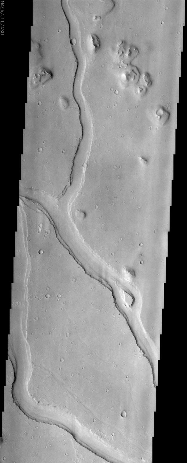
Hebrus Valles is located in the Elysium Planitia region of the northern lowlands of the planet. This image shows three sinuous tributaries of the channel system which carved up the surrounding plains. These individual tributaries are up to 3 km wide and have up to three terraces visible along their margins. These terraces may indicate separate flood events or may be the result of one flood plucking away at channel wall materials with varying strengths of resistance. It is not clear if these are separate rock layers or just the erosion of one type of material from rising and falling water levels. A streamlined island is visible in the lower third of the image. This feature indicates that flow was from the lower right to upper left in this region (the tail of the island points downstream). In places ripples, interpreted to be dunes, can also be seen along the interface of the channel floor with the walls. Smaller, fainter channels can also be seen scouring the plains, especially in the lower portion of this image. Other features of note in this image are the various inselbergs (isolated hills) located primarily in the upper portion of the image. The inselbergs are surrounded with aprons of material that was probably shed off of the hills by various processes of erosion.
The Story
Mars was once the scene of some major floods that rushed out upon the land, carving all kinds of channels. These signs of ancient flooding have always been exciting to scientists who want to understand the history of water on the planet. Water is important to understanding the climate and geological history of Mars, as well as whether life could ever have developed there.
While we can't tell much about the life question from pictures like this one, it does give some insights into the great flood itself. You can see three tributaries of a channel system that are up to two miles wide or so.
The really interesting thing is that you can see terraces of land that step down from the sides of the tributaries. How did they form? Was there one massive flood that swept through, eroding materials with varying strengths of resistance? Or was it several, separate floods? And what could the answer tell us about the types of rocks and materials in this region? No one knows if these are separate rock layers or just one type of material that has eroded from rising and falling water levels.
While these questions will continue to intrigue geologists, one thing that they can tell for sure is the direction the water flowed. Can you find the tear-drop shaped island in the now dry channel? On Earth, we see these islands created in rivers all the time. The "tail" of the island (the point on the teardrop) points downstream, so that means the flood rushed down the channel from the lower right to the upper left.
Since the flood, there is some rippling evidence on the channel floor that dunes may have formed. Smaller, fainter channels can also be seen scouring the plains, especially in the lower portion of this image. Other interesting features in this image are the various inselbergs (isolated hills) located primarily in the upper portion of the image. The inselbergs are surrounded with aprons of material that was probably shed off of the hills by various processes of erosion.
- Image Credit:
-
NASA/JPL/Arizona State University
Image Addition Date: -
2002-06-17
|
 Planetary Data System


