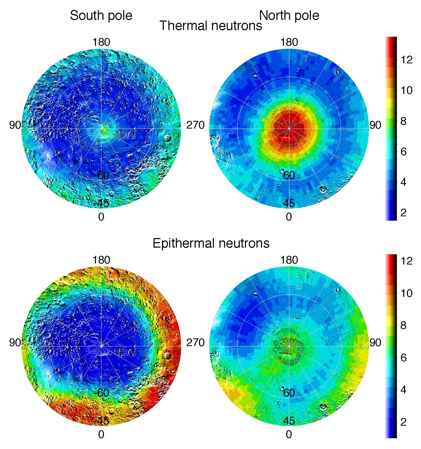
Observations by NASA's 2001 Mars Odyssey spacecraft show views of the polar regions of Mars in thermal neutrons (top) and epithermal neutrons (bottom). In these maps, deep blue indicates a low amount of neutrons, and red indicates a high amount. Thermal neutrons are sensitive to the presence of hydrogen and the presence of carbon dioxide, in this case "dry ice" frost. The red area in the upper right map indicates that about one meter (three feet) of carbon dioxide frost covers the surface around the north pole, as it does every Mars winter in the polar regions. An enhancement of thermal neutrons close to the south pole, seen as a light green color on the upper left map, indicates the presence of residual carbon dioxide in the south polar cap, even though the annual frost dissipated from that region during southern summer. Soil enriched with hydrogen is indicated by the deep blue colors on the epithermal maps (bottom), showing a low intensity of epithermal neutrons. The deep blue areas in the polar regions are believed to contain up to 50 percent water ice in the upper one meter (three feet) of the soil. The views shown here are of measurements made during the first three months of mapping using the neutron spectrometer instrument, part of the gamma ray spectrometer instrument suite. Topographic features are superimposed on the map for geographic reference.
NASA's Jet Propulsion Laboratory manages the 2001 Mars Odyssey mission for NASA's Office of Space Science, Washington, D.C. Investigators at Arizona State University in Tempe, the University of Arizona in Tucson, and NASA's Johnson Space Center, Houston, operate the science instruments. The gamma-ray spectrometer was provided by the University of Arizona in collaboration with the Russian Aviation and Space Agency, which provided the high-energy neutron detector, and the Los Alamos National Laboratories, New Mexico, which provided the neutron spectrometer. Lockheed Martin Astronautics, Denver, is the prime contractor for the project, and developed and built the orbiter. Mission operations are conducted jointly from Lockheed Martin and from JPL, a division of the California Institute of Technology in Pasadena.
 Planetary Data System


