- Original Caption Released with Image:
-
(Released 30 April 2002)
The Science
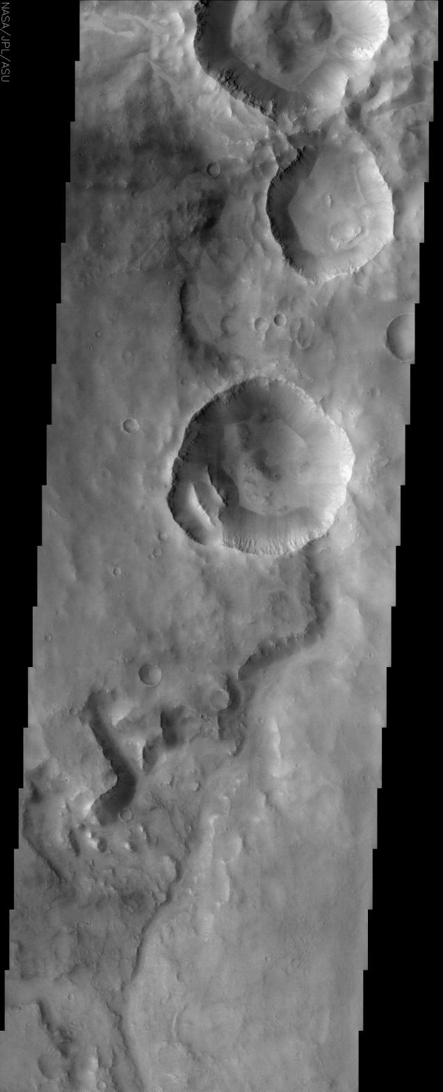
This THEMIS visible image shows a region in Terra Meridiani near -12° S, 358° W (2° E). An old, heavily degraded channel can be seen from the lower (southern) portion of the image toward the top. This channel appears to terminate abruptly at the rim of a 10 km diameter crater. This apparent "superposition" of the crater on top of the channel suggests that the impact crater was created after the channel was formed. This crater has two 3-km sized blocks of material that have slumped off from the lower left segment of the original crater rim. These immense blocks must have moved as a single unit because the rock layers that can be seen in the original wall of the crater can still be seen in these detached blocks. The walls of several craters in this image show vague hints of possible gully formation at the bottom of pronounced rock layers, with the suggestion of alcoves above the individual gullies. Well-developed gullies that were imaged by the Mars Orbiter Camera (MOC) on Mars Global Surveyor have been suggested to form by seepage and runoff of a fluid. The MOC has observed these gullies in numerous craters and channels further south, but they are uncommon at latitudes this close to the equator. Several sections of the crater walls appear to have ridges and troughs formed by the dry avalanche of loose rock, and a similar process of dry avalanche may account for the gullies seen in this THEMIS image. Patches of lighter material, possibly small dunes ripples, can be seen in several places throughout this image.
The Story
When the walls come tumbling down! Take a closer look at the bright linear ridges within a deep crater near the center of this image (bottom, left-hand side of the crater). Almost 2 miles long, these chunks of material slumped off the crater side in one fell swoop. Phoozhj! Down they came as one massive unit. You can tell, because the rock layers seen in the original wall of the crater are also still there in the detached material as well.
Instability in the craters doesn't stop there. Other ridges and troughs in the large craters were probably formed by smaller avalanches of loose rock, but . . . what about those gullies? Were they caused by small, dry avalanches too, or could they possibly have been formed by some kind of liquid running down the walls?
In the grand search for possible signs of water on the red planet, gullies found in craters around Mars have been a source of speculation and great interest. The walls of several craters in this image show vague hints of possible gully formation, and features like "alcoves" above the individual gullies suggest a possible "formation by fluid." And yet, gullies are usually found in the south of Mars, not along the equatorial region where these craters are located. So, . . . who knows? This area will take a lot of further study.
A long, snaky channel also winds its way up from the bottom of this image, only to be obliterated in its path by the large crater pits that came later. Eroded and old, the channel is far less dramatic than the large impact craters, but leaves a record of more ancient processes on Mars.
Dappled in light and dark terrain, the texture of this cratered region of Mars is actually quite complex, especially when you look at the close-up image. Beyond the predominant craters, a smattering of smaller, shallower craters dot the surface, and signs of bright dunes can be found as well.
- Image Credit:
-
NASA/JPL/Arizona State University
Image Addition Date: -
2002-05-23
|
 Planetary Data System


