PDS logoPlanetary Data System
PDS Information
Find a Node - Use these links to navigate to any of the 8 publicly accessible PDS Nodes.

This bar indicates that you are within the PDS enterprise which includes 6 science discipline nodes and 2 support nodes which are overseen by the Project Management Office at NASA's Goddard Space Flight Center (GSFC). Each node is led by an expert in the subject discipline, supported by an advisory group of other practitioners of that discipline, and subject to selection and approval under a regular NASA Research Announcement.
Click here to return to the Photojournal Home Page Click here to view a list of Photojournal Image Galleries Photojournal_inner_header
Latest Images  |  Spacecraft & Technology  |  Animations  |  Space Images App  |  Feedback  |  Photojournal Search  

PIA03765: Uzboi Vallis, Nirgal Vallis, and Luki Crater
 Target Name:  Mars
 Is a satellite of:  Sol (our sun)
 Mission:  2001 Mars Odyssey
 Spacecraft:  2001 Mars Odyssey
 Instrument:  THEMIS
 Product Size:  1210 x 3061 pixels (w x h)
 Produced By:  Arizona State University
 Producer ID:  20020409A
 Full-Res TIFF:  PIA03765.tif (1.812 MB)
 Full-Res JPEG:  PIA03765.jpg (449.6 kB)

Click on the image above to download a moderately sized image in JPEG format (possibly reduced in size from original)

Original Caption Released with Image:


(Released 9 April 2002)
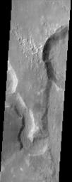
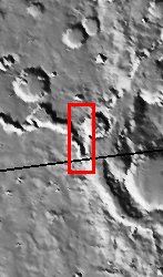
This THEMIS image captures two channels (Nirgal Vallis is the smaller sinuous channel on the left and Uzboi Vallis is the larger channel located in the lower right) and Luki Crater located in the upper right. The mouth of Nirgal Vallis appears to be truncated by Uzboi Vallis. This indicates that Nirgal Vallis is an older channel than Uzboi Vallis. The floor of Uzboi Vallis was subsequently bombarded by an asteroid or comet which gouged out the 21 km diameter crater named Luki. Luki is named after a town in the Ukraine. Uzboi is the name of a dry river in Russia. Nirgal is the Babylonian name for Mars. Gullies and alluvial deposits discovered by Mars Global Surveyor are clearly visible on the polar-facing (south) wall and floor of Nirgal Vallis and also in the inner rim of Luki crater. These gullies appear to emanate from a specific layer in the walls. There is a pronounced sparsity of gullies on the equator-ward facing slopes but some are present in this image. The gullies have been proposed to have formed by the subsurface release of water. The western channel wall of Uzboi Vallis does not appear to have the fine-scale gullying as does Nirgal Vallis. However, the western channel wall of Uzboi Vallis does show some evidence of downslope movement (mass wasting). Some patches of dunes are also seen on the channel floor, notably along the edges of the channel floor near the canyon walls. There is also a landslide located along the southern wall of Luki Crater.
Image Credit:
NASA/JPL/Arizona State University

Image Addition Date:
2002-05-21