In the high plateau of southwestern Bolivia, two large salt deserts, or playas, are located between the eastern and western Andes. The Salar de Uyuni is the largest and highest playa in the world, encompassing an area of more than 9000 square kilometers and situated more than 3600 meters above sea level. It is separated by a range of hills from its smaller neighbor to the north, the Salar de Coipasa. During the Pleistocene the climate of the region was wetter and the entire area was covered by a massive lake. As the waters slowly dried, abundant dissolved minerals were left behind to form the playas. The salt pans are now excellent indicators of rainfall fluctuations within the region and are also important sites for the study of paleoclimatology.
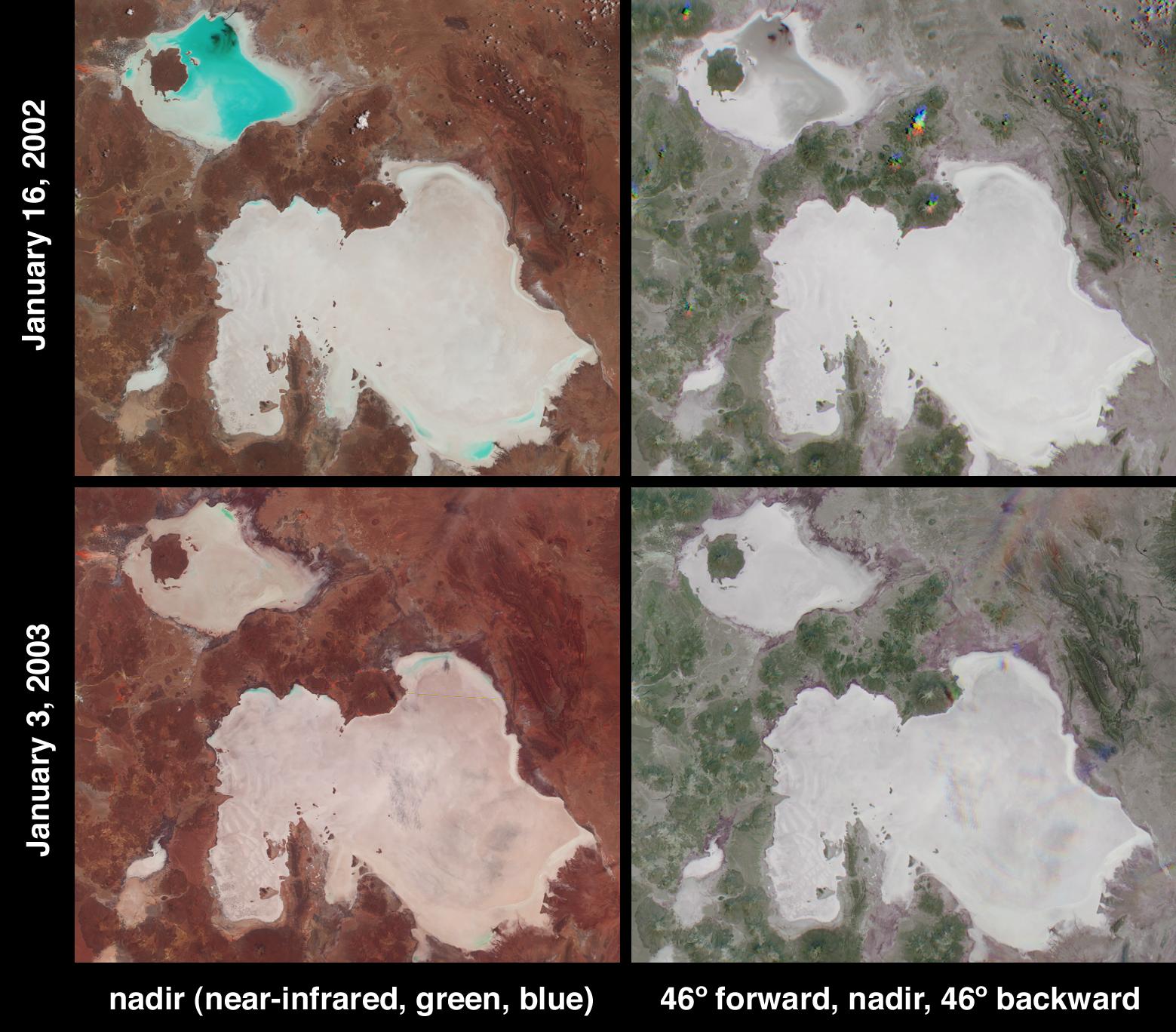
These two image pairs from the Multi-angle Imaging SpectroRadiometer (MISR) depict the playas on January 16, 2002 and January 3, 2003. At this time of year the wet season has already begun, and the Salar de Coipaso is usually at least partially flooded. Data from these two dates were processed identically to preserve relative variations in brightness between them. Varying degrees of surface moisture around the two playas are illustrated by the different display techniques of the right and left-hand panels.
At left are two false-color views acquired by MISR's nadir camera. Data from the near-infrared, green and blue bands are displayed as red, green and blue. This spectral display causes bright, wet surfaces to appear blue-green because water selectively absorbs longer wavelengths such as near-infrared. Significantly more standing water is present in the Salar de Coipaso in 2002 than in 2003. However, a stronger signal at the near-infrared band on the 2003 date, which causes the overall hue in the 2003 image to be redder than 2002, suggests an increase in photosynthetic activity (plant growth) at the 2003 date compared with one year earlier.
The right-hand panels were created using only red band data, and are multi-angle composites in which color variations serve as a proxy for changes in angular reflectance. Data from the 46-degree forward, nadir and 46-degree backward-viewing cameras are displayed here as red, green and blue. The angular composites contain information relating to surface moisture and/or texture characteristics that are not apparent with a single view. In the southern hemisphere, the backward pointing cameras receive a stronger signal from surfaces which predominantly forward scatter sunlight (which generally tend to be smooth and/or wet surfaces). The salt encrusted playas appear bright white and gray but the edges of the playas and some smaller salt flats exhibit a purple-blue hue that corresponds with enhanced forward scattering, possibly caused by greater moisture content of these soils. If this interpretation is correct, it indicates that the soil moisture content is greater around the playa perimeters on the 2003 date.
Thin, wispy clouds that are almost invisible over the Salar de Uyuni in the nadir 2003 image are also more easily identified using the composite views, since geometric parallax associated with the clouds' elevation above the surface causes the individual camera images to be spatially separated.
The Multi-angle Imaging SpectroRadiometer observes the daylit Earth continuously and every 9 days views the entire globe between 82 degrees north and 82 degrees south latitude. These data products were generated from a portion of the imagery acquired during Terra orbits 11071 and 16197. The panels cover an area of 199 kilometers x 174 kilometers, and utilize data from blocks 106 to 107 within World Reference System-2 path 233.
 Planetary Data System


