The answers to this quiz appear in blue below each question.
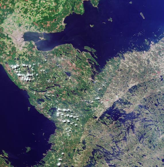
1. The location of a city is indicated by the pale gray-colored pixels in
the upper left. Three of the following four statements about this city are
true. Which statement is false?
(A) No city with a larger population is located within 4 degrees latitude.
(B) The city was established about 300 years ago.
(C) There are hundreds of bridges within the metropolitan area, of which
only one is a drawbridge.
(D) A linear feature connecting the island to the right of the city with the
mainland supports automotive but not rail traffic.
Answer: C is false
The image has been rotated such that north is toward the bottom. The city
in the south eastern portion of the image is Russia's St. Petersburg, which
is the most northerly large city in the world at almost 60 degrees north
latitude. The closest city with a larger population, Moscow, is south of St.
Petersburg by more than 4 degrees (at 55.75 degrees north). St. Petersburg
was established along the banks of the Neva River by Peter the Great in
1703. This marshy, low-lying area possesses many rivers and islands, and
about 300 bridges, of which more than twenty are drawbridges. The island
connected with the north shore of Petersburg is called Kotlin Island and is
the home of the famous naval fortress of Kronstadt. The road built upon a
tidal barrage connecting the island with the mainland is open to road traffic
but does not support a railway.
2. A large blue water body extends along the top portion of the image.
Three of these four statements about it are true. Which statement is false?
(A) The shores provide an important habitat for at least one type of seal.
(B) Dreissena polymorpha, an invasive pest species, has been found in
these waters.
(C) These waters are more salty than most other seas.
(D) Forest products account for at least half of all cargo leaving one of the
major ports along the shoreline.
Answer: C is false
The water body extending along the top portion of the image is the Gulf of
Finland. These shores are home to the Grey Seal and the Ringed Seal. The
bivalve Dreissena polymorpha has been recorded in the eastern parts of the
Gulf of Finland since the 1980's. The Gulf of Finland is a low salinity marine
environment, and one of the freshest enclosed seas in the world. Over half
of all cargo leaving the Finnish port of Hamina are forest products.
3. Another large body of water stretches along the left-hand portion of the
image. Three of these statements about this water body are true. Which
statement is false?
(A) Its maximum depth is less than 300 meters.
(B) There is an active monastery on one of its islands.
(C) It is the main source of freshwater for the region and is currently
threatened by pollution.
(D) Its basin is of tectonic origin and was formed through movements of
the Earth's crust.
Answer: D is false
The waters stretching along the left are part of Lake Ladoga. Despite being
somewhat shallow (the maximum depth of the lake is about 230 meters), Lake
Ladoga is the largest freshwater lake in Europe and the primary source of
drinking water for St. Petersburg. Pollution from various industrial and
agricultural materials threaten the Lagoda water supply. The large island of
Valaam (in the lower-left portion of the image area) houses an active
monastery that dates from the 12th century. The origin of the lake is related
to the recent glacial history of the area and not to tectonic deformations of
the Earth's crust.
4. Extending from the bottom center of the image to the water's edge in
the upper right quadrant is a curvilinear boundary separating darker
shades of green on the left from lighter hues of green and brown on the
right. Three of the following four statements about this feature are true.
Which one is false?
(A) It coincides with a political border.
(B) It is associated with an escarpment more than 500 meters in elevation.
(C) It demarcates areas characterized by historically different logging practices.
(D) It is traversed by a river in which salmon and trout migration has been affected
by the construction of a hydroelectric plant.
Answer: B is false
The curvilinear feature coincides with the southern portion of the border between
Russia and Finland. The maximum elevation in this region is less than 200 meters.
For much of the 20th century, Russia's westernmost border served as a barrier to
international interaction, and the forests in this region were largely excluded from
the international trade in forest products. In contrast, forests along the Finnish side
of the border have been more intensively exploited during the past century. The
Vuoksi River crosses this border at the twin cities of Imatra, Finland and Svetogorsk,
Russia, and then flows onward toward Lake Ladoga. The Imatrankoski power station
and dam which was constructed between these towns in the 1920's has hindered
salmon and trout migrations along this route.
MISR was built and is managed by NASA's Jet Propulsion Laboratory,
Pasadena, CA, for NASA's Office of Earth Science, Washington, DC. The
Terra satellite is managed by NASA's Goddard Space Flight Center,
Greenbelt, MD. JPL is a division of the California Institute of
Technology.