The answers to this quiz appear in blue below each question.
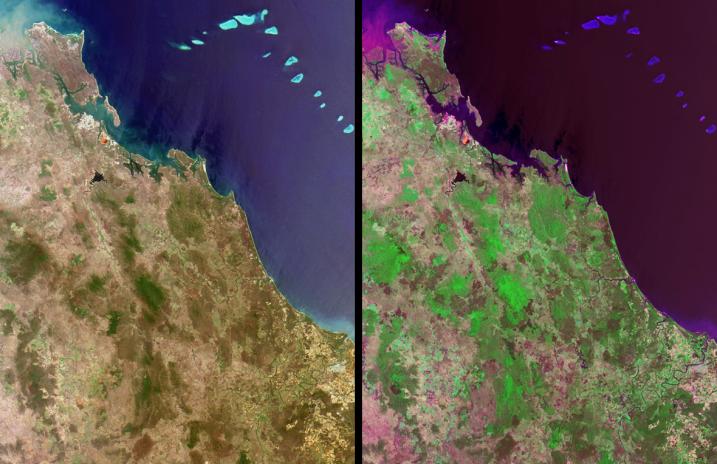
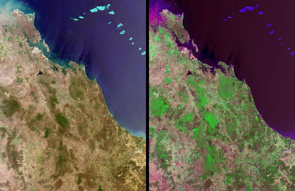
1. In the upper left-hand corner, the ocean waters exhibit a murky
appearance due to a large amount of sediment being discharged
from a river mouth. For whom is the river named and what office did
this person hold?
The Fitzroy River shown in this image is in Queensland, Australia, and
reaches the sea at the town of Rockhampton. It should not be confused
with a river of the same name in Western Australia. Queensland's Fitzroy
River was named in the mid 1850's in honor of Sir Charles Fitzroy, former
Governor of New South Wales and Governor-General of the Australian
Colonies.
2. In the upper left-hand quadrant of these images, a small, bright
reddish-orange feature is apparent near the coast in both the natural
and false-color views. The cause of this reddish-orange feature is:
(A) The recurrence of a bloom of red algae.
(B) An abundance of naturally-occurring iron deposits.
(C) A modern art installation financed by a private consortium.
(D) Waste from a mineral manufacturing and refining process.
Answer: D
The reddish-orange feature is a result of residue ponds at the Boyne
Island alumina plant and smelter, south of the town of Gladstone,
where raw bauxite from various mines across Australia is digested to
produce nearly 5 million tons of aluminum oxide per year. The red
color is caused by hydroxides of iron that exist as impurities within
the bauxite.
3. A distinctively-shaped, dark-colored reservoir with a sinewy river
at one end is located to the south of the aforementioned reddish-orange
feature. This reservoir is the main water supply for a nearby industrial and
urban region. When these images were acquired, the water level within
this reservoir was at about 45% of total capacity. Over the next six months,
did the water level in the reservoir rise or fall?
This time of year normally marks the start of the rainy season; however,
the water level of Lake Awoonga fell from about 24.5 meters to about
23.5 meters between late November 2001 and late April 2002 due to
local drought conditions.
4. A small seaside town within the image area (situated just over halfway
down this length of coastline) was named to commemorate the year
when a group of global explorers first set foot in this locality. What is the
name of the town?
The town of Seventeen-seventy is so named because in May of 1770,
Captain James Cook anchored along this part of the coast and made the
second onshore visit to Australian soil, and the first venture onto dry land
in what is now called Queensland.
5. In the lower right-hand quadrant of these images, a large winding river
flows through an agricultural region. Endemic only to the upper reaches
of this and a few other nearby rivers is an endangered fish with a peculiar
anatomical characteristic. Name the fish.
The Queensland (or Australian) Lungfish (Neoceratodus forsteri) is a
representative of an ancient group of fishes that have survived many
millions of years and is unusual because of its possession of a single lung.
This fish was restricted to the Burnett River (the winding river in the lower
right) and to the Mary River, but has recently been successfully reintroduced
to a number of other nearby rivers.
MISR was built and is managed by NASA's Jet Propulsion Laboratory,
Pasadena, CA, for NASA's Office of Earth Science, Washington, DC. The
Terra satellite is managed by NASA's Goddard Space Flight Center,
Greenbelt, MD. JPL is a division of the California Institute of
Technology.
 Planetary Data System


