This island is Bouvet Island (or Bouvetøya) and is a territory of Norway.
The answers to this quiz appear in blue below each question.
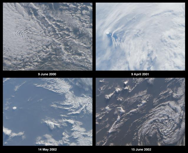
1. The images contain multiple clues that can be used to determine whether
the observed area is situated in the northern or southern hemisphere.
Name the hemisphere and describe at least two clues you used to establish
your answer. (Clues should not make use of knowledge of the island's
identity.)
Answer:
The region shown is in the southern hemisphere.
There are 5 clues which can be used to determine hemisphere:
- The clockwise rotation of the decaying cyclonic circulation in the lower
right-hand panel;
- Brightness changes between the panels indicate that June is closer to
mid-winter (June image appears darker than May image which is darker than
April);
- Shadows from cumulus clouds (especially visible in the lower panels) are
cast toward the south, thus the sun is north of the clouds;
- The northern sides of these clouds are more brightly illuminated than their
southern sides, also indicating that the sun is to the north;
- Shadows are longer in June than in May.
(Note: The westerly wind direction cannot be used as a reliable indicator
of hemisphere, and westerlies can curve to the north or south in both
hemispheres. Westerly winds do indicate that the region is probably at mid
to high latitudes.)
2. Three of the following four statements about the island's environment
are true. Which one is false?
A. Glaciers cover most of the island, and vegetation is limited to lichen
sand mosses.
B. The island is of volcanic origin and located at the intersection of
oceanic ridges.
C. A colony of Atlantic puffins makes the island its home.
D. The highest peak rises more than 750 meters above sea level.
Answer: C
The Atlantic Puffin (Fraterculus arctica) cannot be found here since the
Puffin is restricted to the northern hemisphere. This small volcanic island
is situated at the intersection of the Mid-Atlantic Ridge (southern extremity),
the America-Antarctic Ridge, and the Atlantic Indian Ridge. Vegetation at
this permanently glaciated isle is restricted to lichens and mosses. The
highest peak (Olavtoppen) rises to 780 meters (2560 feet).
3. Three of the following four statements about the history of the island
are true. Which one is false?
A. Sovereignty over the island was transferred from one country to another
sometime between 1918 and 1932.
B. Steep cliffs make the island difficult to access, and despite many
attempts the first landing did not take place until the 1850's.
C. In the 19th century, a whaling/sealing expedition christened the island
with the name of a city located in their native country.
D. The earliest documented discovery of the island was by an 18th century
French explorer, and the island is currently named after this individual.
Answer: B
The island was first sighted in 1738 by French explorer Jean-Baptiste Charles
Bouvet de Lozier. Bouvet was convinced it was the northernmost tip of
Antarctica but could not circumnavigate or land upon the island due to
severe weather. Steep cliffs surrounding most sides of the island also made
access difficult, and after various attempts, a landing was made in 1822 by
an American sealer, Benjamin Morrell, who named the island after Bouvet.
A British whaling/sealing expedition arrived three years later and named it
Liverpool Island. The Norwegians claimed sovereignty of the island in 1928,
and they renamed it in honor of Bouvet during their expedition of 1929.
4. All five of the following events took place, but only four occurred
during the second half of the 20th century. Which one did not occur in
this time period?
A. The island and adjacent waters were designated a nature reserve.
B. A weather station was established on the island, providing automated
temperature and pressure data.
C. A nuclear bomb test occurred within 3000 kilometers of the island.
D. An abandoned boat of unknown origin was discovered on the island.
E. The island's seals were declared to be protected species.
Answer: E (see note below)
(A) Bouvetøya became a Nature Reserve in 1971
(B) An automated weather station was established in 1977
(C) A nuclear bomb was detonated between Bouvetøya and Marion Island
in 1979
(D) A lifeboat and supplies were discovered on the island in 1964, but their
origin could not be determined.
(E) Seals in the area were declared to be protected in 1935. However, this
protection was incorporated into international agreement in 1959.
*Respondents who noted this ambiguity were given credit for this question.
5. What is the name of the island and to which country does it belong?
Answer: The island is Bouvet Island (or Bouvetøya) and is a territory of Norway.
MISR was built and is managed by NASA's Jet Propulsion Laboratory,
Pasadena, CA, for NASA's Office of Earth Science, Washington, DC. The
Terra satellite is managed by NASA's Goddard Space Flight Center,
Greenbelt, MD. JPL is a division of the California Institute of
Technology.
 Planetary Data System


