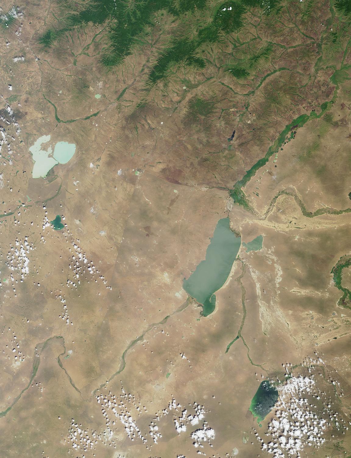
This region of central Asia is situated at the juncture of Mongolia,
China and Russia. The large lakes apparent in the image form geographic
reference points and fall on or near political boundaries. The light-blue
lakes in the upper left are Russia's Torey Lakes (also spelled Torei or
Tooroi Lakes), situated near the border with Mongolia.
The answers to this quiz appear in blue below each question.
1. Near the left-hand edge, above image center, are two light-blue lakes
separated by a narrow strip of land. Three of the following four
statements about them are true. Which one is false?
A. The lakes are in a depression formed by tectonic and volcanic activity.
B. Several rare and endangered bird species breed here.
C. The dominant species of fish is the weather fish, Misgurnus fossilis.
D. Water levels can vary considerably, causing changes to the size of
exposed islands.
Answer: C
This region of central Asia is situated at the juncture of Mongolia, China and
Russia. The large lakes apparent in the image form geographic reference points
and fall on or near political boundaries. The light-blue lakes in the upper left are
Russia's Torey Lakes (also spelled Torei or Tooroi Lakes), situated near the
border with Mongolia. The Torey Lakes form an important part of the
Mongol-Manzurian steppe and wetland ecosystems, and are known as breeding,
feeding and staging areas for millions of migratory waterfowl, including six species
of rare cranes, the Relic gull and the Great Bustard. The dominant fish in the lakes
is the Crucian Carp (Carassius auratus), although the weatherfish (Misgurnus
fossilis) is also present. The lakes are situated in a basin formed by tectonic and
volcanic activities associated with the Central Asian rift system, and the water
level of these saline lakes shows dramatic variation. Islands are exposed when
water levels are low, and the lakes have been known to retreat entirely.
2. To the right of image center is a large lake. About 30 kilometers
northwest of the northern tip of this lake is a border city, which from
1913 to 1949 had a different name than the one it goes by today. Three of
the following four statements about the city are true. Which one is false?
A. Coal mining and food processing are important to the local economy.
B. Transshipment facilities for handling crude oil are planned, but have
not yet been constructed.
C. Mammoth fossils have been discovered here.
D. Railway passengers can cross the border into this city on the #20 train.
Answer: B
The largest lake in the image area is Hulun Nur (or Hulun Hu), part of China's
Inner Mongolian Autonomous Region. A linear feature visible between Torey
Lakes and Hulun Nur closely follows part of the boundary between Mongolia
and China. The Russian / Chinese border in this area is situated north of Hulun
Nur, near the city of Manzhouli (or Manchouli), sometimes called a "Gate to
China". Manzhouli was known as Lubin from 1913 until 1949. The city developed
after the construction of the trans-Manchurian train, and until recent years was
the main center for trade between Russia and China. Trains between Moscow
and Beijing stop at Manzhouli (train numbers 19 and 20). China imports and
transships crude oil via the city, and facilities for transshipment of oil were expanded
in 2000. Important industries include coal mining and the production of food and wool.
The region is also of archaeological interest; a large mammoth skeleton excavated
from one of the coal mines near Manzhouli is on display at the Inner Mongolia
Museum in Huhhot, Inner Mongolia, China.
3. In the lower right-hand quadrant of the image is a blue-green lake
partially obscured by some cumulus clouds. This lake is part of a nation
whose capital city contains a landmark square named for a national hero.
A statue in the square portrays this individual (choose one):
A. At the helm of a ship
B. Seated on a throne
C. Standing in the company of another person
D. On horseback
Answer: D
The lake in the lower right of the image area is called Buyr Nuur (or Buir Nur), and is
part of eastern Mongolia. Mongolia's capital city is Ulaanbaatar (outside the area
covered by this image). Ulaanbaatar's main square is named for Damdiny Sukhbataar,
the hero of Mongolian independence from China. The centerpiece of Sukhbataar
Square is a statue depicting Sukhbataar on horseback.
MISR was built and is managed by NASA's Jet Propulsion Laboratory,
Pasadena, CA, for NASA's Office of Earth Science, Washington, DC. The
Terra satellite is managed by NASA's Goddard Space Flight Center,
Greenbelt, MD. JPL is a division of the California Institute of
Technology.
