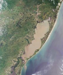
The "Lagoa dos Patos," in the Brazilian state of Rio Grande do Sul,
translates to "the Duck Lagoon." It was named by 16th century Jesuit
settlers, who asked the King of Spain to grant them title to the lagoon
so that they could breed ducks. The King consented, but revoked his edict
when he discovered that the "duck-pond" (measuring about 14,000 square
kilometers) was one of the largest lagoonal systems in the world.
The answers to this quiz appear in blue below each question.
1. The large lagoon in the image is named for a particular type of bird. Name the bird.
The "Lagoa dos Patos," in the Brazilian state of Rio Grande do Sul, translates to
"the Duck Lagoon". It was named by 16th century Jesuit settlers, who asked the
King of Spain to grant them title to the lagoon so that they could breed ducks. The
King consented, but revoked his edict when he discovered that the "duck-pond"
(measuring about 14,000 square kilometers) was one of the largest lagoonal
systems in the world.
2. Note the sediment plume emanating from the southern end of the lagoon. Sailors
in the 16th century imagined this outlet to be the mouth of a large river. What did
they call the
river?
Early Portuguese explorers mistook the entrance to the lagoon for the mouth of a
great river and called it the Rio Grande.
3. A series of wave-like points and curls form "cusps" on the inner shores of the lagoon.
Which ONE of the following is most responsible for the formation of these cusps?
A. Violent storm impacts on erosion and accretion
B. Wind and tide-driven sediment transport and circulation
C. Tectonic folding associated with nearby mountain ridges
D. Bathymetric effects of dredging operations
Answer: B
The lagoon's characteristics change with short-term tide-induced cyclic perturbations,
and with longer term large scale meteorological conditions. The distinctive wavelike
"cusps" along the inner shores result from the circulation, erosion and accumulation
of sediments driven by wind and tidal action.
4. True or false: Changes in regional precipitation associated with large scale atmospheric
circulation patterns have no effect on the salinity of the lagoon's water.
Answer: FALSE
The El Niño Southern Oscillation (ENSO) circulation affects precipitation amount and
continental runoff, thereby changing the contents of the lagoon waters. High rainfall
and increased freshwater discharge of El Niño correspond with elevated dissolved
nutrient concentrations and increased phytoplankton growth. La Niña years are dry,
and low rainfall reduces the freshwater recharge to the lagoon, causing an increase
in salinity.
5. Which one of these is NOT distributed within the area covered by this image?
A. Ruppia maritima
B. Chelonia mydas
C. Tapirus bairdii
D. Microcystis aeruginosa
Answer: C
Occasional blooms of toxic cyanobacteria (Microcystis aeruginosa), have been
registered in the lagoon when nutrient concentrations are elevated. A number of
reeds and grasses are important to the lagoon estuary, including widgeon grass
(Ruppia maritima) which reaches peak production during summer. Sea turtles
(Chelonia mydas) can be found in the lagoon during spring and summer. Although
the lowland tapir (Tapirus terrestris) is found in some parts of Rio Grande do Sul,
the Baird's tapir (Tapirus bairdii), is not distributed within the image area (it is
restricted to Central America).
MISR was built and is managed by NASA's Jet Propulsion Laboratory,
Pasadena, CA, for NASA's Office of Earth Science, Washington, DC. The
Terra satellite is managed by NASA's Goddard Space Flight Center,
Greenbelt, MD. JPL is a division of the California Institute of
Technology.

 Planetary Data System


