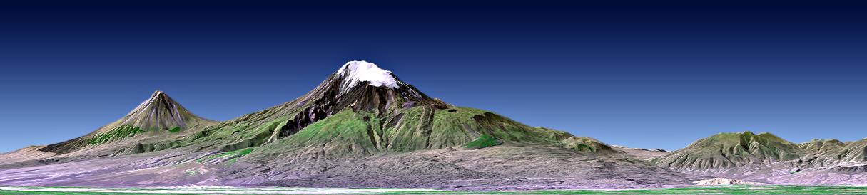
This perspective view shows Mount Ararat in easternmost Turkey, which has been the site of several searches for the remains of Noah's Ark. The main peak, known as Great Ararat, is the tallest peak in Turkey, rising to 5165 meters (16,945 feet). This southerly, near horizontal view additionally shows the distinctly conically shaped peak known as "Little Ararat" on the left. Both peaks are volcanoes that are geologically young, but activity during historic times is uncertain.
This image was generated from a Landsat satellite image draped over an elevation model produced by the Shuttle Radar Topography Mission (SRTM). The view uses a 1.25-times vertical exaggeration to enhance topographic expression. Natural colors of the scene are enhanced by image processing, inclusion of some infrared reflectance (as green) to highlight the vegetation pattern, and inclusion of shading of the elevation model to further highlight the topographic features.
Volcanoes pose hazards for people, the most obvious being the threat of eruption. But other hazards are associated with volcanoes too. In 1840 an earthquake shook the Mount Ararat region, causing an unstable part of mountain's north slope to tumble into and destroy a village. Visualizations of satellite imagery when combined with elevation models can be used to reveal such hazards leading to disaster prevention through improved land use planning.
But the hazards of volcanoes are balanced in part by the benefits they provide. Over geologic time volcanic materials break down to form fertile soils. Cultivation of these soils has fostered and sustained civilizations, as has occurred in the Mount Ararat region. Likewise, tall volcanic peaks often catch precipitation, providing a water supply to those civilizations. Mount Ararat hosts an icefield and set of glaciers, as seen here in this late summer scene, that are part of this beneficial natural process
Elevation data used in this image was acquired by the Shuttle Radar Topography Mission (SRTM) aboard the Space Shuttle Endeavour, launched on February 11, 2000. SRTM used the same radar instrument that comprised the Spaceborne Imaging Radar-C/X-Band Synthetic Aperture Radar (SIR-C/X-SAR) that flew twice on the Space Shuttle Endeavour in 1994. SRTM was designed to collect three-dimensional measurements of the Earth's surface. To collect the 3-D data, engineers added a 60-meter-long (200-foot) mast, installed additional C-band and X-band antennas, and improved tracking and navigation devices. The mission is a cooperative project between the National Aeronautics and Space Administration (NASA), the National Geospatial-Intelligence Agency (NGA) of the U.S. Department of Defense (DoD), and the German and Italian space agencies. It is managed by NASA's Jet Propulsion Laboratory, Pasadena, CA, for NASA's Earth Science Enterprise, Washington, DC.
View Size: 124 kilometers (77 miles) wide, 148 kilometers (92 miles) distance
Location: 39.7 degrees North latitude, 44.3 degrees East longitude
Orientation: Looking South, 2 degrees down from horizontal, 1.25X vertical exaggeration
Image Data: Landsat Bands 1, 2+4, 3 as blue, green, red respectively
Date Acquired: February 2000 (SRTM), August 31, 1989 (Landsat)
 Planetary Data System


