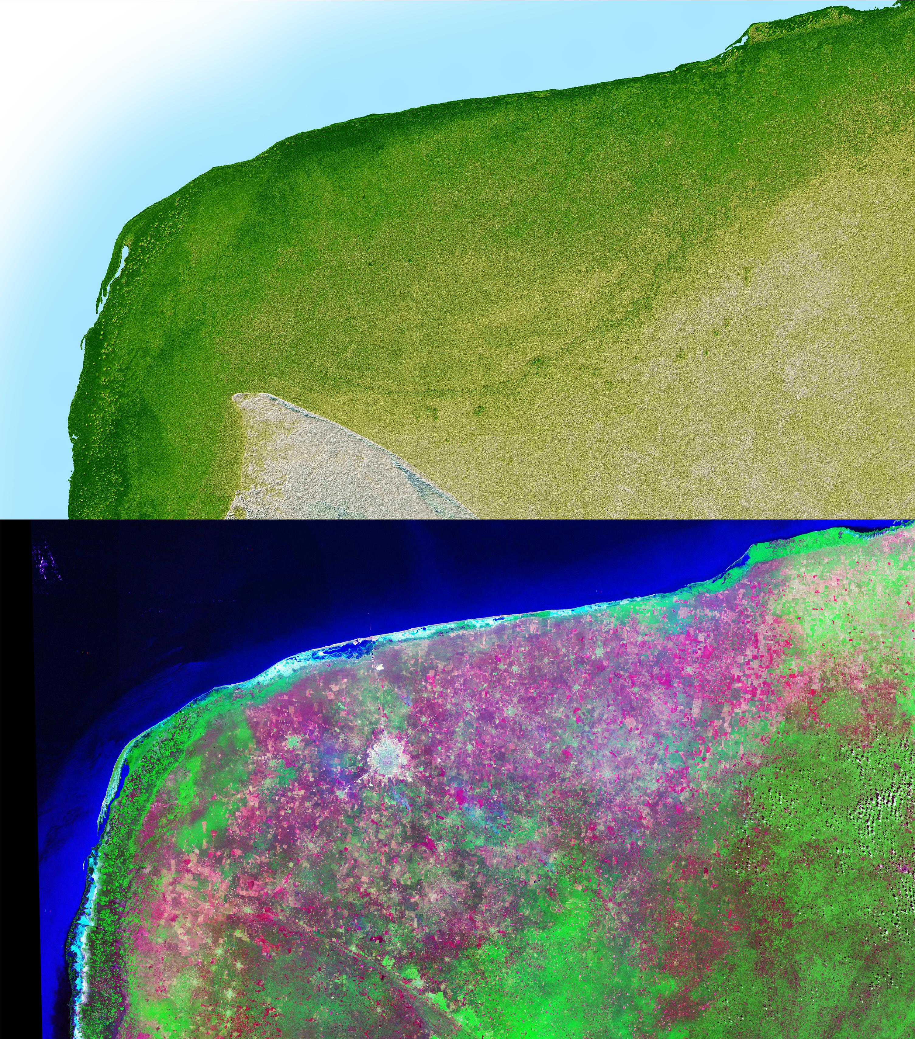
The top picture is a shaded relief image of the northwest corner of Mexico's Yucatan Peninsula generated from Shuttle Radar Topography Mission (SRTM) data, and shows a subtle, but unmistakable, indication of the Chicxulub impact crater. Most scientists now agree that this impact was the cause of the Cretatious-Tertiary Extinction, the event 65 million years ago that marked the sudden extinction of the dinosaurs as well as the majority of life on Earth. The pattern of the crater's rim is marked by a trough, the darker green semicircular line near the center of the picture. This trough is only about 3 to 5 meters (10 - 15 feet) deep and is about 5 km (3 miles) wide; so subtle that if you walked across it you probably would not notice it. It is the surface expression of the buried crater's outer boundary. Scientists believe the impact, which was centered just off the coast in the Caribbean, altered the subsurface rocks such that the overlying limestone sediments, which formed later and erode very easily, would preferentially erode along the crater rim. This formed the trough as well as numerous sinkholes (called cenotes) which are visible as small circular depressions.
The bottom picture is the same area viewed by the Landsat satellite, and was made by displaying the Thematic Mapper's Band 7 (mid-infrared), Band 4 (near-infrared) and Band 2 (green) as red, green and blue. These colors were chosen to maximize the contrast between different vegetation and land cover types, with native vegetation and cultivated land showing as green, yellow and magenta, and urban areas as white. The circular white area near the center of the image is Merida, a city of about 720,000 population. Notice that in the SRTM image, which shows only topography, the city is not visible, while in the Landsat image, which does not show elevations, the trough is not visible.
Two visualization methods were combined to produce the SRTM image: shading and color coding of topographic height. The shade image was derived by computing topographic slope in the northwest-southeast direction, so that northwest slopes appear bright and southeast slopes appear dark. Color coding is directly related to topographic height, with green at the lower elevations, rising through yellow and tan, to white at the highest elevations.
Elevation data used in this image were acquired by the Shuttle Radar Topography Mission (SRTM) aboard the Space Shuttle Endeavour, launched on Feb. 11, 2000. SRTM used the same radar instrument that comprised the Spaceborne Imaging Radar-C/X-Band Synthetic Aperture Radar (SIR-C/X-SAR) that flew twice on the Space Shuttle Endeavour in 1994. SRTM was designed to collect 3-D measurements of the Earth's surface. To collect the 3-D data, engineers added a 60-meter (approximately 200-foot) mast, installed additional C-band and X-band antennas, and improved tracking and navigation devices. The mission is a cooperative project between NASA, the National Imagery and Mapping Agency (NIMA) of the U.S. Department of Defense and the German and Italian space agencies. It is managed by NASA's Jet Propulsion Laboratory, Pasadena, Calif., for NASA's Earth Science Enterprise, Washington, D.C.
Size: 261 by 162 kilometers (162 by 100 miles)
Location: 20.8 degrees North latitude, 89.3 degrees West longitude
Orientation: North toward the top, Mercator projection
Image Data: shaded and colored SRTM elevation model
Original Data Resolution: SRTM 1 arcsecond (about 30 meters or 98 feet)
Date Acquired: February 2000
 Planetary Data System


