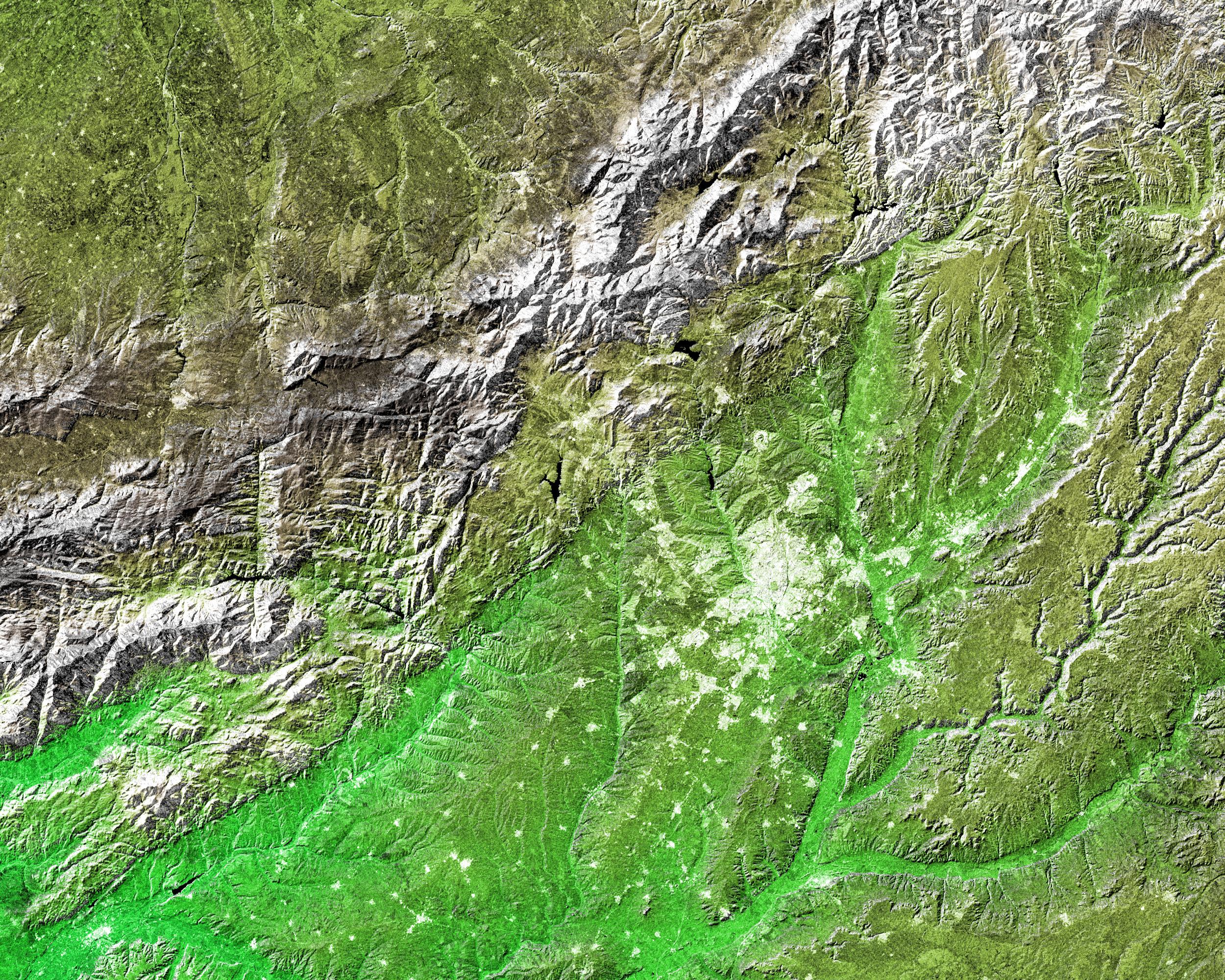
The white, mottled area in the right-center of this image from NASA's Shuttle Radar Topography Mission (SRTM) is Madrid, the capital of Spain. Located on the Meseta Central, a vast plateau covering about 40 percent of the country, this city of 3 million is very near the exact geographic center of the Iberian Peninsula. The Meseta is rimmed by mountains and slopes gently to the west and to the series of rivers that form the boundary with Portugal. The plateau is mostly covered with dry grasslands, olive groves and forested hills.
Madrid is situated in the middle of the Meseta, and at an elevation of 646 meters (2,119 feet) above sea level is the highest capital city in Europe. To the northwest of Madrid, and visible in the upper left of the image, is the Sistema Central mountain chain that forms the "dorsal spine" of the Meseta and divides it into northern and southern subregions. Rising to about 2,500 meters (8,200 feet), these mountains display some glacial features and are snow-capped for most of the year. Offering almost year-round winter sports, the mountains are also important to the climate of Madrid.
Three visualization methods were combined to produce this image: shading and color coding of topographic height and radar image intensity. The shade image was derived by computing topographic slope in the northwest-southeast direction. North-facing slopes appear bright and south-facing slopes appear dark. Color coding is directly related to topographic height, with green at the lower elevations, rising through yellow and brown to white at the highest elevations. The shade image was combined with the radar intensity image in the flat areas.
Elevation data used in this image was acquired by the SRTM aboard the Space Shuttle Endeavour, launched on Feb. 11, 2000. SRTM used the same radar instrument that comprised the Spaceborne Imaging Radar-C/X-Band Synthetic Aperture Radar (SIR-C/X-SAR) that flew twice on the Space Shuttle Endeavour in 1994. SRTM was designed to collect 3-D measurements of the Earth's surface. To collect the 3-D data, engineers added a 60-meter (approximately 200-foot) mast, installed additional C-band and X-band antennas, and improved tracking and navigation devices. The mission is a cooperative project between NASA, the National Imagery and Mapping Agency (NIMA) of the U.S. Department of Defense and the German and Italian space agencies. It is managed by NASA's Jet Propulsion Laboratory, Pasadena, Calif., for NASA's Earth Science Enterprise, Washington, D.C.
Size: 172 by 138 kilometers (107 by 86 miles)
Location: 40.43 degrees North latitude, 3.70 degrees West longitude
Orientation: North toward the top
Image Data: shaded and colored SRTM elevation model, with SRTM radar intensity added
Original Data Resolution: SRTM 1 arcsecond (about 30 meters or 98 feet)
Date Acquired: February 2000
