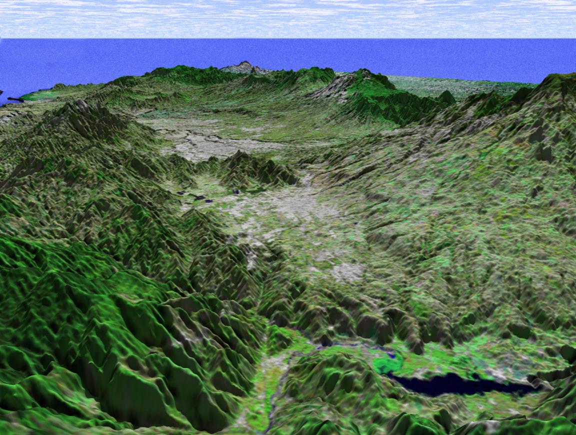
This perspective view shows the capital city of San Jose, Costa Rica, the gray area in the center of the image. The view is toward the northwest with the Pacific Ocean in the distance and shows a portion of the Meseta Central (Central Valley), home to about a third of Costa Rica's population.
Like much of Central America, Costa Rica is generally cloud covered, so very little satellite imagery is available. The ability of the Shuttle Radar Topography Mission (SRTM) instrument to penetrate clouds and make three-dimensional measurements will allow generation of the first complete high-resolution topographic map of the entire region. These data were used to generate the image.
This three-dimensional perspective view was generated using elevation data from SRTM and an enhanced false-color Landsat 7 satellite image. Colors are from Landsat bands 5, 4, and 2 as red, green and blue, respectively. Topographic expression is exaggerated two times.
Landsat has been providing visible and infrared views of the Earth since 1972. SRTM elevation data matches the 30-meter resolution of most Landsat images and will substantially help in analyses of the large and growing Landsat image archive. The Landsat 7 Thematic Mapper image used here was provided to the SRTM by the United States Geological Survey, Earth Resources Observation Systems (EROS) Data Center, Sioux Falls, S.D.
Elevation data used in this image was acquired by the SRTM aboard the Space Shuttle Endeavour, launched on February 11, 2000. SRTM used the same radar instrument that comprised the Spaceborne Imaging Radar-C/X-Band Synthetic Aperture Radar (SIR-C/X-SAR) that flew twice on the Space Shuttle Endeavour in 1994. SRTM was designed to collect three-dimensional measurements of the Earth's surface. To collect the 3-D data, engineers added a 60-meter-long (200-foot) mast, installed additional C-band and X-band antennas, and improved tracking and navigation devices. The mission is a cooperative project between NASA, the National Imagery and Mapping Agency (NIMA) of the U.S. Department of Defense (DoD), and the German and Italian space agencies. It is managed by NASA's Jet Propulsion Laboratory, Pasadena, Calif., for NASA's Earth Science Enterprise, Washington, D.C.
Size: scale varies in this perspective image
Location: 10.0 degrees North latitude, 83.8 degrees West longitude
Orientation: looking Northwest
Image Data: Landsat Bands 5, 4, 3 as red, green, blue respectively
Original Data Resolution: SRTM 30 meters (99 feet)
Date Acquired: February 2000 (SRTM)
 Planetary Data System


