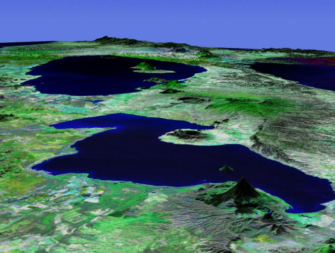
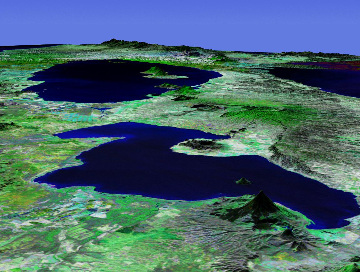
This perspective view shows Lakes Managua and Nicaragua near the Pacific coast of Nicaragua. Lake Managua is the 65-kilometer (40-mile)-long fresh water lake in the foreground of this south-looking view, emptying via the Tipitapa River into the much larger Lake Nicaragua in the distance. The capital city of Managua, with a population of more than 500,000, is located along the southern shore of Lake Managua, the area with the highest population density in Nicaragua.
The physical setting of Lake Managua is dominated by the numerous volcanic features aligned in a northwest-southeast axis. The cone-like feature in the foreground is Momotombo, a 1,280-meter (4,199-foot)-high stratovolcano located on the northwest end of the lake. Two water-filled volcanic craters (Apoyegue and Jiloa volcanoes) reside on the Chiltepe Peninsula protruding into the lake from the west. Two volcanoes can also be seen on the island of Ometepe in Lake Nicaragua: El Maderas rising to 1,394 meters (4,573 feet) and the active El Conception at 1,610 meters (5,282 feet).
This three-dimensional perspective view was generated using topographic data from the Shuttle Radar Topography Mission (SRTM) and an enhanced false-color Landsat 7 satellite image. Colors are from Landsat bands 5, 4, and 2 as red, green and blue, respectively. Topographic expression is exaggerated two times.
Landsat has been providing visible and infrared views of the Earth since 1972. SRTM elevation data matches the 30-meter resolution of most Landsat images and will substantially help in analyses of the large and growing Landsat image archive. The Landsat 7 Thematic Mapper image used here was provided to the SRTM by the United States Geological Survey, Earth Resources Observation Systems (EROS) Data Center, Sioux Falls, S.D.
Elevation data used in this image was acquired by the SRTM aboard the Space Shuttle Endeavour, launched on February 11, 2000. SRTM used the same radar instrument that comprised the Spaceborne Imaging Radar-C/X-Band Synthetic Aperture Radar (SIR-C/X-SAR) that flew twice on the Space Shuttle Endeavour in 1994. SRTM was designed to collect three-dimensional measurements of the Earth's surface. To collect the 3-D data, engineers added a 60-meter-long (200-foot) mast, installed additional C-band and X-band antennas, and improved tracking and navigation devices. The mission is a cooperative project between NASA, the National Imagery and Mapping Agency (NIMA) of the U.S. Department of Defense (DoD), and the German and Italian space agencies. It is managed by NASA's Jet Propulsion Laboratory, Pasadena, Calif., for NASA's Earth Science Enterprise, Washington, D.C.
Size: scale varies in this perspective image
Location: 12.1 degrees North latitude, 86.1degrees West longitude
Orientation: looking South
Image Data: Landsat bands 5, 4, 3 as red, green, blue respectively
Original Data Resolution: SRTM 30 meters (99 feet)
Date Acquired: February 2000 (SRTM)