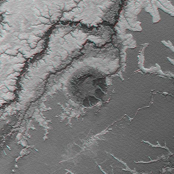
An 8-kilometer (5-mile) wide crater of possible impact origin is shown in this anaglyph view of an isolated part of the Bolivian Amazon derived from a Shuttle Radar Topography Mission (SRTM) elevation model. The circular feature at the center of the image, known as the Iturralde Structure, is possibly the Earth's most recent "big" impact event recording collision with a meteor or comet that might have occurred between 11,000 and 30,000 years ago.
Although the structure was identified on satellite photographs in the mid-1980s, its location is so remote that it has only been visited by scientific investigators twice, most recently by a team from NASA's Goddard Space Flight Center in September 2002. Lying in an area of very low relief, the landform is a quasi-circular closed depression only about 20 meters (66 feet) in depth, with sharply defined sub-angular "rim" materials. It resembles a "cookie cutter" in that its appearance "cuts" the heavily vegetated soft-sediments and pampas of this part of Bolivia. The SRTM data have provided investigators with the first topographic map of the site and will allow studies of its three-dimensional structure crucial to determining whether it actually is of impact origin.
Thick vegetation in part defines the surface that the SRTM radar sees as it maps the terrain. Much of the local "topography" in this area is a measure of tree height (typically up to 13 meters, or 40 feet). This effect is easily seen here, where the ground surface relief is very low. Interpretative separation of the ground surface and vegetative features typically relies upon recognition of their characteristic patterns.
This anaglyph was created by deriving an image of the terrain from the SRTM data, draping it back over the SRTM elevation model, and then generating two differing perspectives, one for each eye. The terrain image depicts a combination of topographic shading (north slopes bright) and topographic height (higher elevations bright). When viewed through special glasses, the anaglyph is a vertically exaggerated view of the Earth's surface in its full three dimensions. Anaglyph glasses cover the left eye with a red filter and cover the right eye with a blue filter.
Elevation data used in this image was acquired by the Shuttle Radar Topography Mission aboard Space Shuttle Endeavour, launched on Feb. 11, 2000. The mission used the same radar instrument that comprised the Spaceborne Imaging Radar-C/X-Band Synthetic Aperture Radar (SIR-C/X-SAR) that flew twice on Endeavour in 1994. The Shuttle Radar Topography Mission was designed to collect 3-D measurements of Earth's surface. To collect the 3-D data, engineers added a 60-meter (approximately 200-foot) mast, installed additional C-band and X-band antennas, and improved tracking and navigation devices. The mission is a cooperative project between NASA, the National Imagery and Mapping Agency (NIMA) of the U.S. Department of Defense, and the German and Italian space agencies. It is managed by NASA's Jet Propulsion Laboratory, Pasadena, Calif., for NASA's Earth Science Enterprise, Washington, D.C.
Size: 0.33 degrees latitude by 0.33 degrees longitude (about 37 by 36 kilometers or 23 by 22 miles)
Location: 12.6 degrees South latitude, 67.7 degrees West longitude
Orientation: North at top, Latitude-Longitude Projection
Original Data Resolution: SRTM 1 arcsecond (about 30 meters or 98 feet)
Date Acquired: February 2000 (SRTM)
 Planetary Data System


