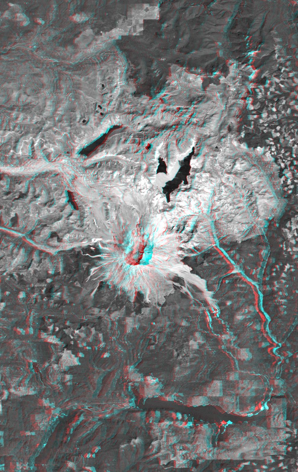
On May 18, 1980, Mount St. Helens catastrophically erupted, causing the worst volcanic disaster in the recorded history of the United States. An earthquake shook loose the northern flank of the volcano, and about 2.8 cubic kilometers (0.67 cubic miles) of rock slid downslope in the world's largest recorded landslide. The avalanche released pressure on the volcano and unleashed a huge explosion, which was directed generally northward. The mountain ultimately lost 227 meters (1314 feet) of its height and devastated about 600 square kilometers (230 square miles) of forest.
This anaglyph combines a Landsat satellite image with a Shuttle Radar Topography Mission elevation model to show the volcanic crater and most of the zone of devastation. Areas now relatively devoid of vegetation appear bright. Note the landslide debris clogging the northern drainages and forming natural dams (or enlarging previously existing ones). Also note the volcanic dome built up within the crater, and the extensive floating debris still present on Spirit Lake (northeast of the crater) 12 years after the eruption.
The stereoscopic effect of this anaglyph was created by first draping a Landsat satellite image over a digital elevation data from the Shuttle Radar Topography Mission (SRTM), and then generating two differing perspectives, one for each eye. When viewed through special glasses, the result is a vertically exaggerated view of the Earth's surface in its full three dimensions. Anaglyph glasses cover the left eye with a red filter and cover the right eye with a blue filter.
Landsat has been providing visible and infrared views of the Earth since 1972. SRTM elevation data matches the 30-meter (98-foot) resolution of most Landsat images and will substantially help in analyzing the large and growing Landsat image archive, managed by the U.S. Geological Survey (USGS).
Elevation data used in this image was acquired by the Shuttle Radar Topography Mission (SRTM) aboard the Space Shuttle Endeavour, launched on Feb. 11, 2000. SRTM used the same radar instrument that comprised the Spaceborne Imaging Radar-C/X-Band Synthetic Aperture Radar (SIR-C/X-SAR) that flew twice on the Space Shuttle Endeavour in 1994. SRTM was designed to collect 3-D measurements of the Earth's surface. To collect the 3-D data, engineers added a 60-meter (approximately 200-foot) mast, installed additional C-band and X-band antennas, and improved tracking and navigation devices. The mission is a cooperative project between NASA, the National Imagery and Mapping Agency (NIMA) of the U.S. Department of Defense and the German and Italian space agencies. It is managed by NASA's Jet Propulsion Laboratory, Pasadena, Calif., for NASA's Earth Science Enterprise, Washington, D.C.
Size: 48.0 kilometers (29.8 miles) by 30.3 kilometers (18.8 miles)
Location: 46.3 degrees North latitude, 122.2 degrees West longitude
Orientation: North at top
Image Data: Landsat Bands 1,2,3 averaged as grey.
Original Data Resolution: SRTM 1 arc-second (30 meters or 98 feet),Landsat 30 meters
Date Acquired: February 2000 (SRTM), 10 August 1992 (Landsat)
 Planetary Data System


