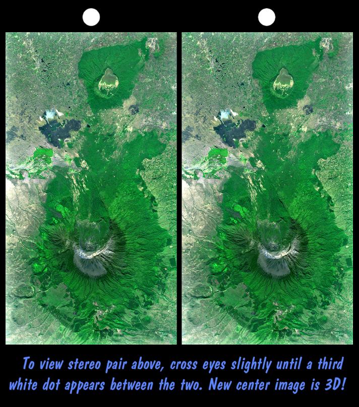
Mount Meru is an active volcano located just 70 kilometers (44 miles) west of Mount Kilimanjaro. It reaches 4,566 meters (14,978 feet) in height but has lost much of its bulk due to an eastward volcanic blast sometime in its distant past, perhaps similar to the eruption of Mount Saint Helens in Washington State in 1980. Mount Meru most recently had a minor eruption about a century ago. The several small cones and craters seen in the vicinity probably reflect numerous episodes of volcanic activity. Mount Meru is the topographic centerpiece of Arusha National Park, but Ngurdoto Crater to the east (image top) is also prominent. The fertile slopes of both volcanoes rise above the surrounding savanna and support a forest that hosts diverse wildlife, including nearly 400 species of birds, and also monkeys and leopards, while the floor of Ngurdoto Crater hosts herds of elephants and buffaloes.
This stereoscopic image was generated by draping a Landsat satellite image over a Shuttle Radar Topography Mission digital elevation model. Two differing perspectives were then calculated, one for each eye. They can be seen in 3-D by viewing the left image with the right eye and the right image with the left eye (cross-eyed viewing or by downloading and printing the image pair and viewing them with a stereoscope. When stereoscopically merged, the result is a vertically exaggerated view of Earth's surface in its full three dimensions.
Landsat has been providing visible and infrared views of the Earth since 1972. SRTM elevation data matches the 30-meter (98-foot) resolution of most Landsat images and will substantially help in analyzing the large and growing Landsat image archive, managed by the U.S. Geological Survey (USGS).
Elevation data used in this image was acquired by the Shuttle Radar Topography Mission (SRTM) aboard the Space Shuttle Endeavour, launched on Feb. 11, 2000. SRTM used the same radar instrument that comprised the Spaceborne Imaging Radar-C/X-Band Synthetic Aperture Radar (SIR-C/X-SAR) that flew twice on the Space Shuttle Endeavour in 1994. SRTM was designed to collect 3-D measurements of the Earth's surface. To collect the 3-D data, engineers added a 60-meter (approximately 200-foot) mast, installed additional C-band and X-band antennas, and improved tracking and navigation devices. The mission is a cooperative project between NASA, the National Imagery and Mapping Agency (NIMA) of the U.S. Department of Defense and the German and Italian space agencies. It is managed by NASA's Jet Propulsion Laboratory, Pasadena, Calif., for NASA's Earth Science Enterprise, Washington, D.C.
Size: 37.1 kilometers (23.0 miles) by 20.3 kilometers (12.6 miles)
Location: 3.2 degrees South latitude, 36.7 degrees East longitude
Orientation: East at top
Image Data: Landsat Bands 3, 2+4, 1 as red, green, blue, respectively.
Original Data Resolution: SRTM 1 arc-second (30 meters or 98 feet)
Date Acquired: February 2000 (SRTM), February 21, 2000 (Landsat 7)
 Planetary Data System


