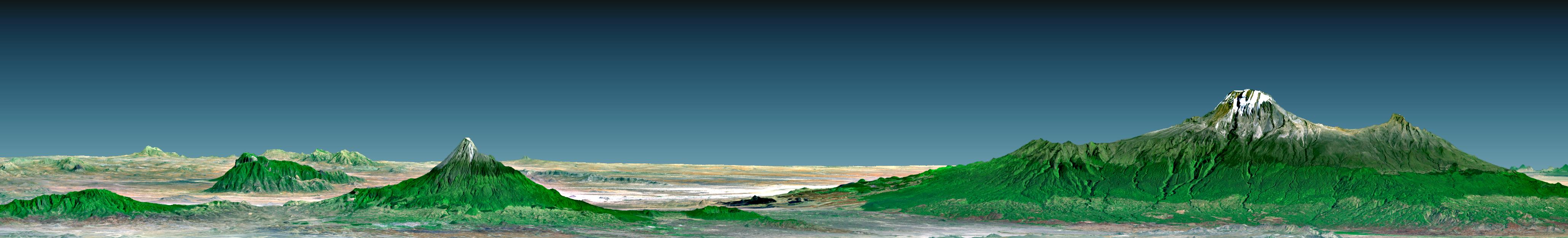
Mount Kilimanjaro (Kilima Njaro or "shining mountain" in Swahili), the highest point in Africa, reaches 5,895 meters (19,340 feet) above sea level, tall enough to maintain a permanent snow cap despite being just 330 kilometers (210 miles) south of the equator. It is the tallest free-standing mountain on the Earth's land surface world, rising about 4,600 meters (15,000 feet) above the surrounding plain. Kilimanjaro is a triple volcano (has three peaks) that last erupted perhaps more than 100,000 years ago but still exudes volcanic gases. It is accompanied by about 20 other nearby volcanoes, some of which are seen to the west (left) in this view, prominently including Mount Meru, which last erupted only about a century ago. The volcanic mountain slopes are commonly fertile and support thick forests, while the much drier grasslands of the plains are home to elephants, lions, and other savanna wildlife.
This 3-D perspective view was generated using topographic data from the Shuttle Radar Topography Mission (SRTM), a Landsat 7 satellite image, and a false sky. Topographic expression is vertically exaggerated two times.
Landsat has been providing visible and infrared views of the Earth since 1972. SRTM elevation data matches the 30-meter (98-foot) resolution of most Landsat images and will substantially help in analyzing the large and growing Landsat image archive, managed by the U.S. Geological Survey (USGS).
Elevation data used in this image was acquired by the Shuttle Radar Topography Mission (SRTM) aboard the Space Shuttle Endeavour, launched on Feb. 11, 2000. SRTM used the same radar instrument that comprised the Spaceborne Imaging Radar-C/X-Band Synthetic Aperture Radar (SIR-C/X-SAR) that flew twice on the Space Shuttle Endeavour in 1994. SRTM was designed to collect 3-D measurements of the Earth's surface. To collect the 3-D data, engineers added a 60-meter (approximately 200-foot) mast, installed additional C-band and X-band antennas, and improved tracking and navigation devices. The mission is a cooperative project between NASA, the National Imagery and Mapping Agency (NIMA) of the U.S. Department of Defense and the German and Italian space agencies. It is managed by NASA's Jet Propulsion Laboratory, Pasadena, Calif., for NASA's Earth Science Enterprise, Washington, D.C.
Size: View width 124 kilometers (77 miles), View distance 166 kilometers (103 miles)
Location: 3 degrees South latitude, 37 degrees East longitude
Orientation: View North, 2 degrees below horizontal, 2 times vertical exaggeration
Image Data: Landsat Bands 3, 2+4, 1 as red, green, blue, respectively.
Original Data Resolution: SRTM 1 arc-second (30 meters or 98 feet), Thematic Mapper 30 meters (98 feet)
Date Acquired: February 2000 (SRTM), A February 21, 2000 (Landsat 7)
 Planetary Data System


