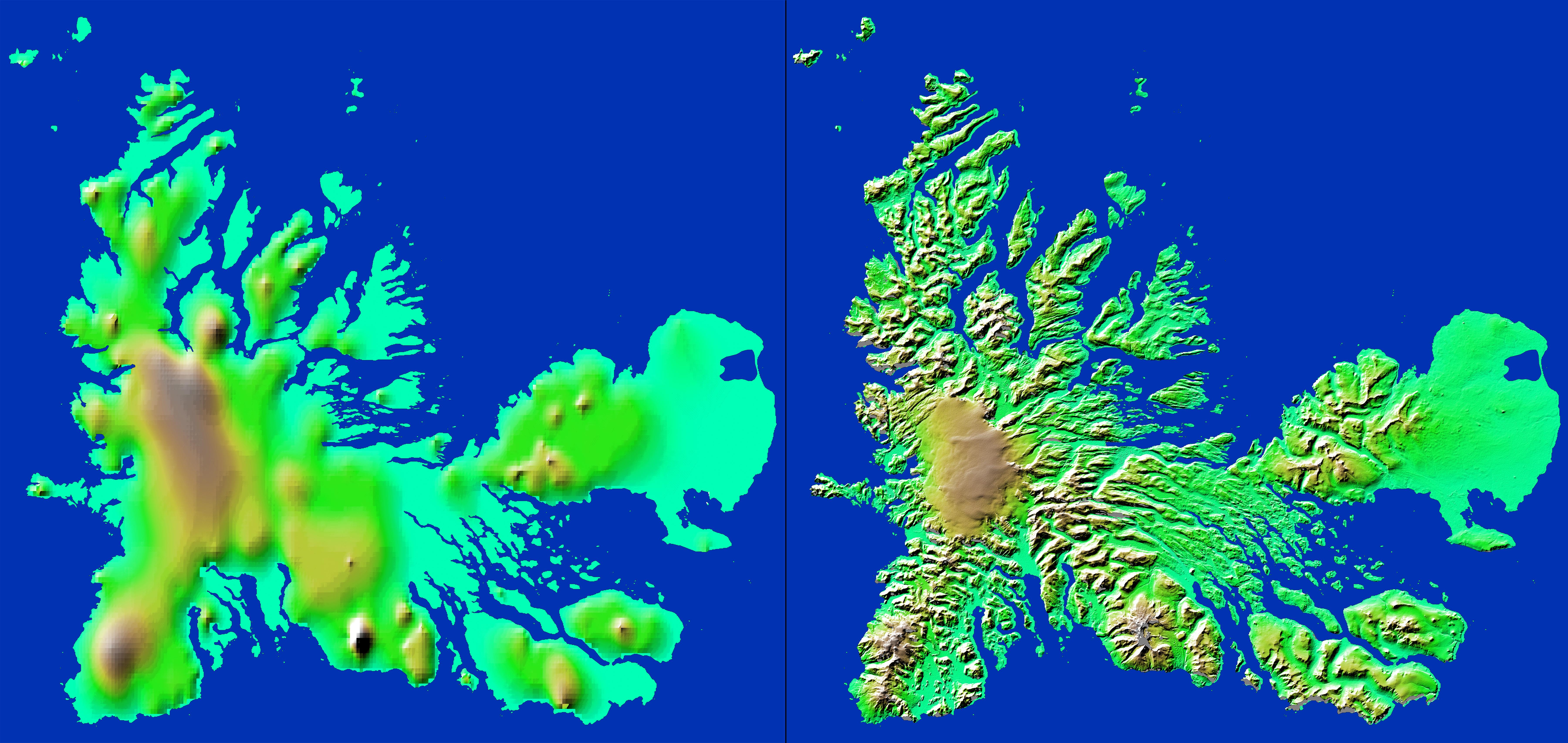
These two images show exactly the same area, Kerguelen Island in the southern Indian Ocean. The image on the left was created using the best global topographic data set previously available, the U.S. Geological Survey's GTOPO30. In contrast, the much more detailed image on the right was generated with data from the Shuttle Radar Topography Mission, which collected enough measurements to map 80 percent of Earth's landmass at this level of precision.
Discovered in 1772 by French navigator Chevalier Yves deKerguelen-Tremarac, Kerguelen is the largest of a group of 300 islands, islets and reefs that make up the Kerguelen Archipelago. The islands lie atop the Kerguelen-Gaussberg Ridge and are built up of a thick series of lava flows with deposits of fragmented volcanic rock and some granite. Ice covers about one-third of the island, with the large Cook Glacier visible as the tan-colored region at the center-left. The highest point at 1,850 meters (6,068 feet) is glacier-covered Mount Ross, located near the bottom center. The coastline of the main island is highly irregular with a large number of peninsulas linked to the island by narrow isthmuses. Remarkably, although the island is 120 by 140 kilometers (75 by 87 miles) in size no point is more than 20 kilometers (12 miles) from the sea.
For some parts of the globe, Shuttle Radar Topography Mission measurements are 30 times more precise than previously available topographical information, according to NASA scientists. Mission data will be a welcome resource for national and local governments, scientists, commercial enterprises, and members of the public alike. The applications are as diverse as earthquake and volcano studies, flood control, transportation, urban and regional planning, aviation, recreation, and communications. The data's military applications include mission planning and rehearsal, modeling, and simulation.
Elevation data used in this image was acquired by the Shuttle Radar Topography Mission aboard Space Shuttle Endeavour, launched on Feb. 11, 2000. The mission used the same radar instrument that comprised the Spaceborne Imaging Radar-C/X-Band Synthetic Aperture Radar (SIR-C/X-SAR) that flew twice on Endeavour in 1994. The Shuttle Radar Topography Mission was designed to collect 3-D measurements of Earth's surface. To collect the 3-D data, engineers added a 60-meter approximately 200-foot) mast, installed additional C-band and X-band antennas, and improved tracking and navigation devices. The mission is a cooperative project between NASA, the National Imagery and Mapping Agency (NIMA) of the U.S. Department of Defense, and the German and Italian space agencies. It is managed by NASA's Jet Propulsion Laboratory, Pasadena, Calif., for NASA's Earth Science Enterprise, Washington, D.C.
Size: 222 kilometers by 146 kilometers (138 miles by 91 miles)
Location: 49.1 degrees South latitude, 69.5 degrees East longitude
Orientation: North is at the top
Date Acquired: February 2000 (SRTM)
 Planetary Data System


