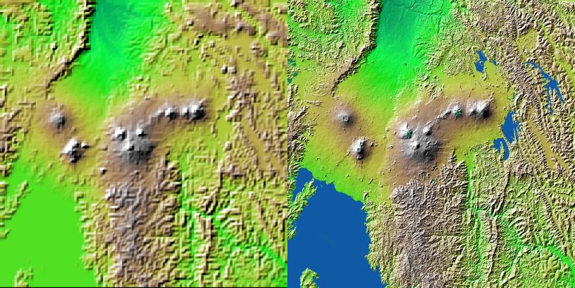
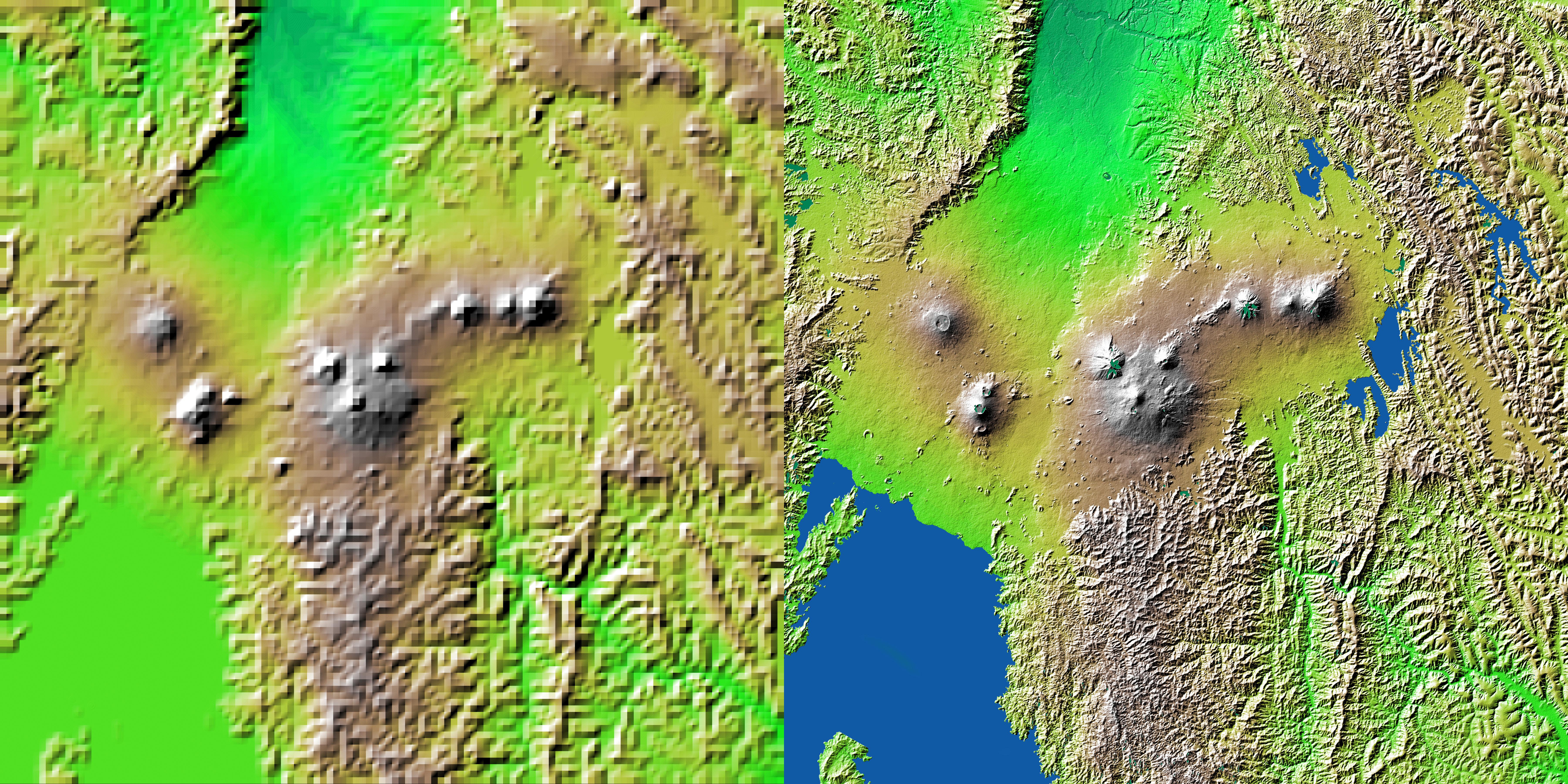
Volcanic, tectonic, erosional and sedimentary landforms are all evident in this comparison of two elevation models of a region along the East African Rift at Lake Kivu. The area shown covers parts of Congo, Rwanda and Uganda.
These two images show exactly the same area. The image on the left was created using the best global topographic data set previously available, the U.S. Geological Survey's GTOPO30. In contrast, the much more detailed image on the right was generated with data from the Shuttle Radar Topography Mission, which collected enough measurements to map 80 percent of Earth's landmass at this level of precision. Elevation is color coded, progressing from green at the lower elevations through yellow to brown at the higher elevations. A false sun in the northwest (upper left) creates topographic shading.
Lake Kivu is shown as black in the Shuttle Radar Topography Mission version (southwest corner). It lies within the East African Rift, an elongated tectonic pull-apart depression in Earth's crust. The rift extends to the northeast as a smooth lava- and sediment-filled trough. Two volcanic complexes are seen in the rift. The one closer to the lake is the Nyiragongo volcano, which erupted in January 2002, sending lava toward the lake shore and through the city of Goma. East of the rift, even more volcanoes are seen. These are the Virunga volcano chain, which is the home of the endangered mountain gorillas. Note that the terrain surrounding the volcanoes is much smoother than the eroding mountains that cover most of this view, such that topography alone is a good indicator of the extent of the lava flows. But this clear only at the higher spatial resolution of the shuttle mission's data set.
For some parts of the globe, Shuttle Radar Topography Mission measurements are 30 times more precise than previously available topographical information, according to NASA scientists. Mission data will be a welcome resource for national and local governments, scientists, commercial enterprises, and members of the public alike. The applications are as diverse as earthquake and volcano studies, flood control, transportation, urban and regional planning, aviation, recreation, and communications. The data's military applications include mission planning and rehearsal, modeling, and simulation.
Elevation data used in this image was acquired by the Shuttle Radar Topography Mission aboard Space Shuttle Endeavour, launched on Feb. 11, 2000. The mission used the same radar instrument that comprised the Spaceborne Imaging Radar-C/X-Band Synthetic Aperture Radar (SIR-C/X-SAR) that flew twice on Endeavour in 1994. The Shuttle Radar Topography Mission was designed to collect 3-D measurements of Earth's surface. To collect the 3-D data, engineers added a 60-meter (approximately 200-foot) mast, installed additional C-band and X-band antennas, and improved tracking and navigation devices. The mission is a cooperative project between NASA, the National Imagery and Mapping Agency (NIMA) of the U.S. Department of Defense, and the German and Italian space agencies. It is managed by NASA's Jet Propulsion Laboratory, Pasadena, Calif., for NASA's Earth Science Enterprise, Washington, D.C.
Size: 1 degree latitude by 1 degree longitude (about 111 x 111 kilometers or 69 x 69 miles)
Location: 1.5 degrees South latitude, 29.5 degrees East longitude
Orientation: North at top
Image: Elevation data, colored height with shaded relief
Original Data Resolution: SRTM 1 arcsecond (about 30 meters or 98 feet), GTOPO30 no greater than 30 arcseconds (about 925 meters or 3000 feet)
Date Acquired: February 2000 (SRTM), Unknown (GTOPO30)
 Planetary Data System


