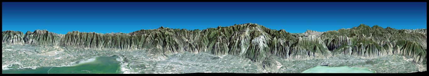
Most of the population of Utah lives just west of the Wasatch Mountains in the north central part of the state. This broad east-northeastward view shows that region with the cities of Ogden, Salt Lake City, and Provo seen from left to right. The Great Salt Lake (left) and Utah Lake (right) are quite shallow and appear greenish in this enhanced natural color view. Thousands of years ago ancient Lake Bonneville covered all of the lowlands seen here. Its former shoreline is clearly seen as a wave-cut bench and/or light colored "bathtub ring" at several places along the base of the mountain front - evidence seen from space of our ever-changing planet.
This 3-D perspective view was generated using topographic data from the Shuttle Radar Topography Mission (SRTM), a Landsat 5 satellite image mosaic, and a false sky. Topographic expression is exaggerated four times.
Landsat has been providing visible and infrared views of the Earth since 1972. SRTM elevation data matches the 30-meter (98-foot) resolution of most Landsat images and will substantially help in analyzing the large and growing Landsat image archive, managed by the U.S. Geological Survey (USGS).
Elevation data used in this image was acquired by the Shuttle Radar Topography Mission (SRTM) aboard the Space Shuttle Endeavour, launched on Feb. 11, 2000. SRTM used the same radar instrument that comprised the Spaceborne Imaging Radar-C/X-Band Synthetic Aperture Radar (SIR-C/X-SAR) that flew twice on the Space Shuttle Endeavour in 1994. SRTM was designed to collect 3-D measurements of the Earth's surface. To collect the 3-D data, engineers added a 60-meter (approximately 200-foot) mast, installed additional C-band and X-band antennas, and improved tracking and navigation devices. The mission is a cooperative project between NASA, the National Imagery and Mapping Agency (NIMA) of the U.S. Department of Defense and the German and Italian space agencies. It is managed by NASA's Jet Propulsion Laboratory, Pasadena, Calif., for NASA's Earth Science Enterprise, Washington, D.C.
Size: View width 147 kilometers (91 miles), View distance 38 kilometers (24 miles)
Location: 40.7 deg. North lat., 112.0 deg. West lon.
Orientation: View 19.5 deg North of East, 20 degrees below horizontal
Image Data: Landsat Bands 3, 2, 1 as red, green, blue, respectively.
Original Data Resolution: SRTM 1 arcsecond (30 meters or 98 feet), Thematic Mapper 30 meters (98 feet)
Date Acquired: February 2000 (SRTM), 1990s (Landsat 5 image mosaic)
 Planetary Data System


