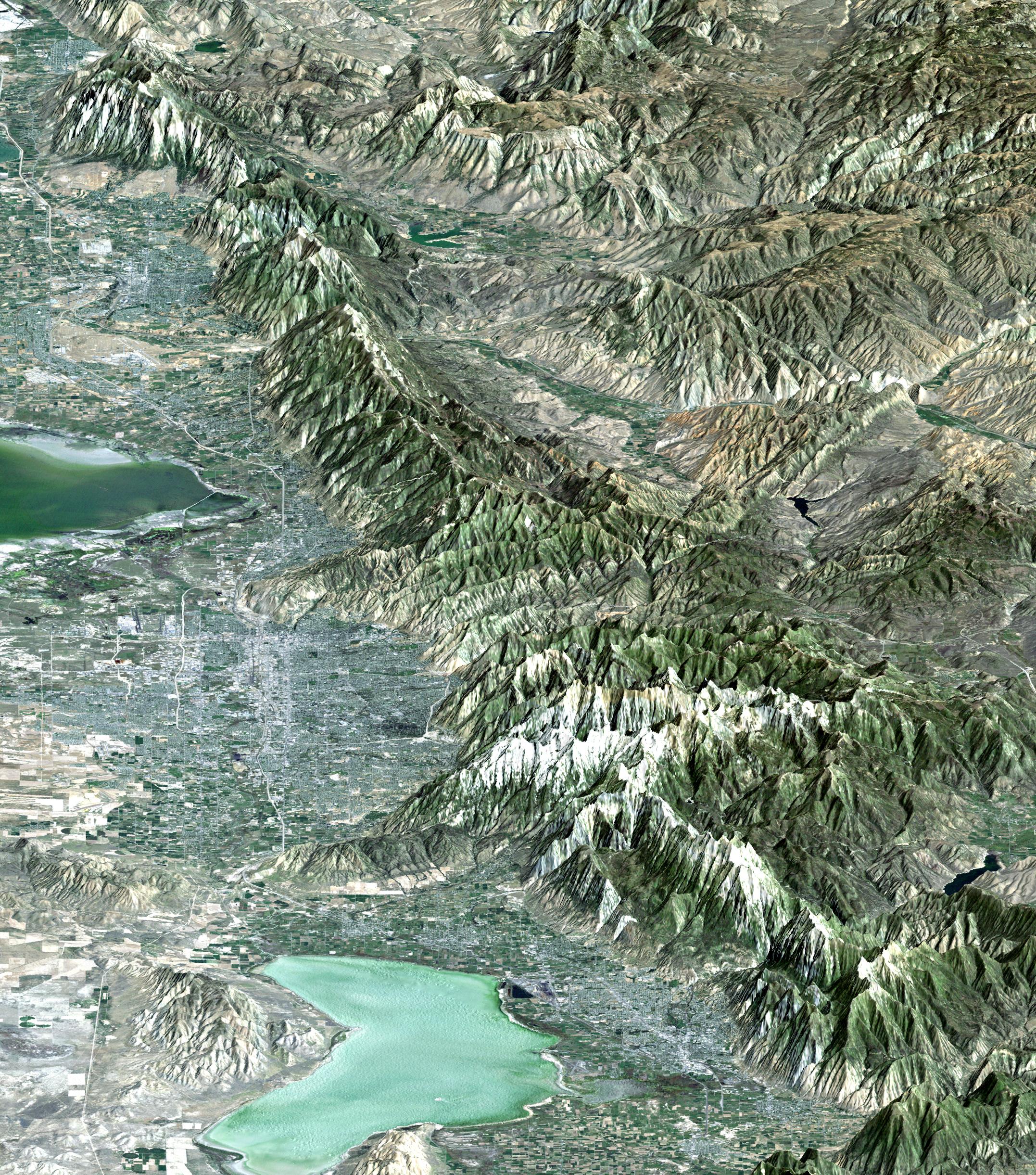
The 2002 Winter Olympics are hosted by Salt Lake City at several venues within the city, in nearby cities, and within the adjacent Wasatch Mountains. This computer generated perspective image provides a northward looking "view from space" that includes all of these Olympic sites. In the south, next to Utah Lake, Provo hosts the ice hockey competition. In the north, northeast of the Great Salt Lake, Ogden hosts curling, and the nearby Snow Basin ski area hosts the downhill events. In between, southeast of the Great Salt Lake, Salt Lake City hosts the Olympic Village and the various skating events. Further east, across the Wasatch Mountains, the Park City area ski resorts host the bobsled, ski jumping, and snowboarding events. The Winter Olympics are always hosted in mountainous terrain. This view shows the dramatic landscape that makes the Salt Lake City region a world-class center for winter sports.
This 3-D perspective view was generated using topographic data from the Shuttle Radar Topography Mission (SRTM) and a Landsat 5 satellite image mosaic. Topographic expression is exaggerated four times.
For a full-resolution, annotated version of this image, please select Figure 1, below:

Landsat has been providing visible and infrared views of the Earth since 1972. SRTM elevation data matches the 30-meter (98-foot) resolution of most Landsat images and will substantially help in analyzing the large and growing Landsat image archive, managed by the U.S. Geological Survey (USGS).
Elevation data used in this image was acquired by the Shuttle Radar Topography Mission (SRTM) aboard the Space Shuttle Endeavour, launched on Feb. 11, 2000. SRTM used the same radar instrument that comprised the Spaceborne Imaging Radar-C/X-Band Synthetic Aperture Radar (SIR-C/X-SAR) that flew twice on the Space Shuttle Endeavour in 1994. SRTM was designed to collect 3-D measurements of the Earth's surface. To collect the 3-D data, engineers added a 60-meter (approximately 200-foot) mast, installed additional C-band and X-band antennas, and improved tracking and navigation devices. The mission is a cooperative project between NASA, the National Imagery and Mapping Agency (NIMA) of the U.S. Department of Defense and the German and Italian space agencies. It is managed by NASA's Jet Propulsion Laboratory, Pasadena, Calif., for NASA's Earth Science Enterprise, Washington, D.C.
Size: View width 48.8 kilometers (30.2 miles), View distance 177 kilometers (110 miles)
Location: 41 deg. North lat., 112.0 deg. West lon.
Orientation: View North, 20 degrees below horizontal
Image Data: Landsat Bands 3, 2, 1 as red, green, blue, respectively.
Original Data Resolution: SRTM 1 arcsecond (30 meters or 98 feet), Thematic Mapper 30 meters (98 feet)
Date Acquired: February 2000 (SRTM), 1990s (Landsat 5 image mosaic)
 Planetary Data System


