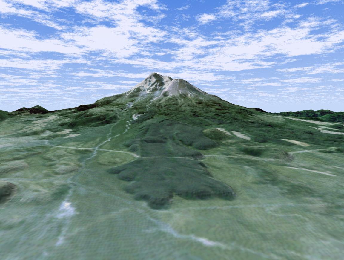
The volcanic nature of Mount Shasta is clearly evident in this computer-generated perspective viewed from the northwest. At over 4,300 meters (14,000 feet), Mount Shasta is California's tallest volcano and part of the Cascade chain of volcanoes extending south from Washington. The twin summits of Shasta and Shastina tower over a lava flow on the flank of the volcano. Cutting across the lava flow is the bright line of a railroad. The bright area at the right edge is the town of Weed.
This 3-D perspective view was generated using topographic data from the Shuttle Radar Topography Mission (SRTM) and an enhanced false-color Landsat 5 satellite image. Colors are from Landsat bands 3, 2, and 1 as red, green and blue, respectively. Topographic expression is exaggerated two times.
Landsat has been providing visible and infrared views of the Earth since 1972. SRTM elevation data matches the 30-meter (98-foot) resolution of most Landsat images and will substantially help in analyzing the large and growing Landsat image archive.
The Landsat Thematic Mapper image used here came from an online mosaic of Landsat images for the continental United States (http://mapus.jpl.nasa.gov), a part of NASA's Digital Earth effort.
Elevation data used in this image was acquired by the Shuttle Radar Topography Mission (SRTM) aboard the Space Shuttle Endeavour, launched on Feb. 11, 2000. SRTM used the same radar instrument that comprised the Spaceborne Imaging Radar-C/X-Band Synthetic Aperture Radar (SIR-C/X-SAR) that flew twice on the Space Shuttle Endeavour in 1994. SRTM was designed to collect 3-D measurements of the Earth's surface. To collect the 3-D data, engineers added a 60-meter (approximately 200-foot) mast, installed additional C-band and X-band antennas, and improved tracking and navigation devices. The mission is a cooperative project between NASA, the National Imagery and Mapping Agency (NIMA) of the U.S. Department of Defense and the German and Italian space agencies. It is managed by NASA's Jet Propulsion Laboratory, Pasadena, Calif., for NASA's Earth Science Enterprise, Washington, D.C.
Size: scale varies in this perspective image
Location: 41.4 degrees North latitude, 122.3 degrees West longitude
Orientation: looking southeast
Image Data: Landsat Bands 3, 2, 1 as red, green, blue, respectively
Original Data Resolution: SRTM 1 arcsecond (30 meters or 98 feet) Thematic Mapper 1 arcsecond (30 meters or 98 feet)
Date Acquired: February 2000 (SRTM)
 Planetary Data System


