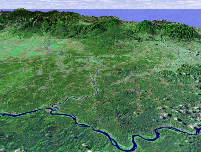
This perspective view shows the northern coastal plain of Costa Rica with the Cordillera Central, composed of a number of active and dormant volcanoes, rising in the background. This view looks toward the south over the Rio San Juan, which marks the boundary between Costa Rica and Nicaragua. The smaller river joining Rio San Juan in the center of the image is Rio Sarapiqui, which is navigable upstream as far inland as Puerto Viejo (Old Port) de Sarapiquí at the mountain's base. This river was an important transportation route for those few hardy settlers who first moved into this region, although as recently as 1953 a mere three thatched-roof houses were all that comprised the village of Puerto Viejo.
This coastal plain is a sedimentary basin formed about 50 million years ago composed of river alluvium and lahar (mud and ash flow) deposits from the volcanoes of the Cordillera Central. It comprises the province of Heredia (the smallest of Costa Rica's seven) and demonstrates a wide range of climatic conditions, from warm and humid lowlands to cool and damp highlands, and including the mild but seasonally wet and dry Central Valley.
This image was generated in support of the Central American Commission for Environment and Development through an agreement with NASA. The Commission involves eight nations working to develop the Mesoamerican Biological Corridor, an effort to study and preserve some of the most biologically diverse regions of the planet.
This three-dimensional perspective view was generated using topographic data from the Shuttle Radar Topography Mission (SRTM) and an enhanced false-color Landsat 7 satellite image. Colors are from Landsat bands 5, 4, and 2 as red, green and blue, respectively. Topographic expression is exaggerated 2X.
Landsat has been providing visible and infrared views of the Earth since 1972. SRTM elevation data matches the 30-meter resolution of most Landsat images and will substantially help in analyses of the large and growing Landsat image archive. The Landsat 7 Thematic Mapper image used here was provided to the SRTM by the United States Geological Survey, Earth Resources Observation Systems (EROS) Data Center, Sioux Falls, South Dakota.
Elevation data used in this image was acquired by the Shuttle Radar Topography Mission (SRTM) aboard the Space Shuttle Endeavour, launched on February 11, 2000. SRTM used the same radar instrument that comprised the Spaceborne Imaging Radar-C/X-Band Synthetic Aperture Radar (SIR-C/X-SAR) that flew twice on the Space Shuttle Endeavour in 1994. SRTM was designed to collect three-dimensional measurements of the Earth's surface. To collect the 3-D data, engineers added a 60-meter-long (200-foot) mast, installed additional C-band and X-band antennas, and improved tracking and navigation devices. The mission is a cooperative project between the National Aeronautics and Space Administration (NASA), the National Imagery and Mapping Agency (NIMA) of the U.S. Department of Defense (DoD), and the German and Italian space agencies. It is managed by NASA's Jet Propulsion Laboratory, Pasadena, CA, for NASA's Earth Science Enterprise,Washington, DC.
Size: scale varies in this perspective image
Location: 10.5 deg. North lat., 84.0 deg. East lon.
Orientation: looking South
Image Data: Landsat Bands 5, 4, 3 as red, green, blue respectively
Original Data Resolution: SRTM 30 meters (99 feet)
Date Acquired: February, 2000 (SRTM)
 Planetary Data System


