PDS logoPlanetary Data System
PDS Information
Find a Node - Use these links to navigate to any of the 8 publicly accessible PDS Nodes.

This bar indicates that you are within the PDS enterprise which includes 6 science discipline nodes and 2 support nodes which are overseen by the Project Management Office at NASA's Goddard Space Flight Center (GSFC). Each node is led by an expert in the subject discipline, supported by an advisory group of other practitioners of that discipline, and subject to selection and approval under a regular NASA Research Announcement.
Click here to return to the Photojournal Home Page Click here to view a list of Photojournal Image Galleries Photojournal_inner_header
Latest Images  |  Spacecraft & Technology  |  Animations  |  Space Images App  |  Feedback  |  Photojournal Search  

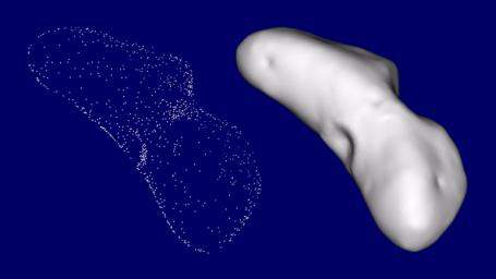
PIA02955: The Shape of Eros
 Target Name:  Eros
 Is a satellite of:  Sol (our sun)
 Mission:  NEAR Shoemaker 
 Spacecraft:  NEAR Shoemaker
 Instrument:  Multi-Spectral Imager 
 Product Size:  883 x 497 pixels (w x h)
 Produced By:  Johns Hopkins University/APL
 Addition Date:  2000-08-05
 Primary Data Set:  NEAR Home Page
 Full-Res TIFF:  PIA02955.tif (262 kB)
 Full-Res JPEG:  PIA02955.jpg (31.46 kB)

Click on the image above to download a moderately sized image in JPEG format (possibly reduced in size from original)

Original Caption Released with Image:

Looking at a few pictures of Eros under the right lighting conditions gives a reasonable idea of the shape of the asteroid, but analysis of NEAR Shoemaker data requires a very accurate digital model of Eros' shape. This "shape model" helps the NEAR team analyze images and other types of data. For example, comparing the brightness of imaged regions with the orientation of the corresponding parts of the surface, taken from the shape model, allows scientists to determine whether bright areas are due to just surface orientation or also to surface properties. By "filling" the shape model with material about Eros' average density, one can calculate the strength and direction of gravity at any point on the surface -- not an easy task on a body as oddly shaped as Eros. Comparing this calculated gravity field with Eros' real field places bounds on the differences in Eros' internal density.

One method of determining the shape is directly from the images. The directions to landmarks in different images are triangulated to determine the landmarks' 3D location. On Eros, the landmarks that we see the best are typically craters and boulders. Once the 3-D locations of enough landmarks have been determined, a continuous surface that passes through these points is generated, giving a good approximation of the shape of the asteroid.

Image Credit:
NASA/JPL/JHUAPL

Image Addition Date:
2000-08-05