
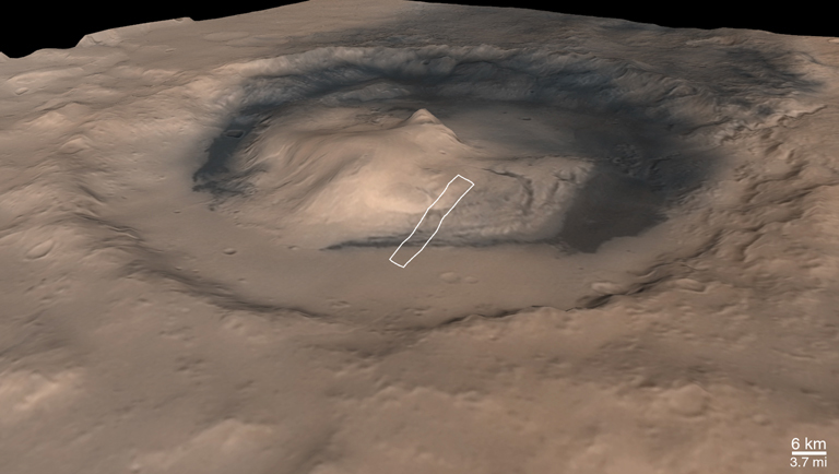
(A) Oblique View Looking Southeastward Across Gale Crater and Central Mound | 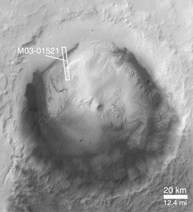
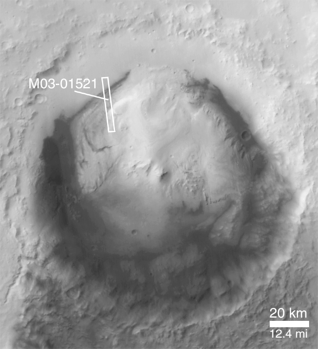
(B) Gale Crater Context Image, North is Up |
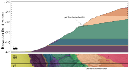
(C) Stratigraphic Cross Section of Gale Crater Mound |
Some exposures of layered material interpreted to be sedimentary rock on Mars are quite thick and reveal a complex history of change. Gale Crater, a basin 172 km (107 mi) in diameter located at 5.4°S, 222.2°W, contains a large central mound of layered rock that, in places, is more than 2.3 km (1.4 mi) thick. The pictures shown here illustrate some of the variety of features that occur in the layered mound, and show that there is evidence for a history that included a hiatus in the deposition of new material, erosion and impact cratering of the material, followed by new deposition on top of the eroded surface.
Picture A shows an oblique view--looking toward the southeast--of Gale Crater and its central mound that was generated by combining Mars Orbiter Camera (MOC) wide angle images with Mars Orbiter Laser Altimeter (MOLA) elevation data from the Mars Global Surveyor (MGS) spacecraft. The white box indicates the location of MOC narrow angle image M03-01521, which was used by MOC scientists to begin the process of deciphering the history recorded in the layers that make up the large central mound. This mound is thought to be a remnant of a once larger deposit that probably filled much or all of Gale Crater and perhaps extended onto the surrounding terrain.
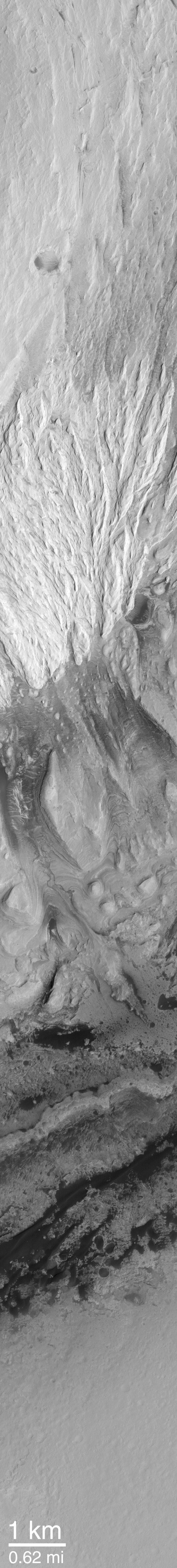
Picture B shows a view of Gale Crater looking straight-down from MGS's ~370 km-high (~230 mi-high) orbit. In this mosaic of MOC wide angle images, north is up, sunlight illuminates the scene from the upper left, and the location of the high resolution view, M03-01521, is again indicated by a white box. Other MOC high resolution views, such as M00-01602, show that the dark material surrounding the mound on the crater floor consists mainly of sand dunes. The high resolution view, MOC image M03-01521, was used to examine the details of layered rock exposed in the Gale Crater central mound. It is shown here with north toward the lower left (so it is oriented roughly the same as is seen in (A)) and illuminated by sunlight from the lower right. Dark sand dunes can be seen near the contact between the crater floor and the mound.
Picture C is an interpreted cross-section through the part of the Gale Crater mound that is visible in MOC image M03-01521. The lower part of Picture C is the image, M03-01521, with each different rock unit (some have many, thin layers, others have few layers, others erode differently or have different brightness, etc.) shown by a different color. The cross section uses the MOLA topographic profile that was acquired by MGS at the same time as the MOC image. The MOLA data give elevations for the area between the two straight black lines running lengthwise across the MOC image. Where the MOLA profile intersects the contact between each colored unit, the position of this unit in the cross section can be inferred. These data and the observations presented in PIA02844 and PIA02845 show that the Gale Crater mound preserves a complex history that includes the formation of many layers in the lower part of the mound, a period of erosion and cratering on these lower layered units, then deposition on top of these materials by younger, brighter, and not-layered (i.e., massive) units.
 Planetary Data System


