PIA02841: Layered Material in West Arabia Terra Crater
 Target Name:  Mars
 Is a satellite of:  Sol (our sun)
 Mission:  Mars Global Surveyor (MGS)
 Spacecraft:  Mars Global Surveyor Orbiter
 Instrument:  Mars Orbiter Camera (MOC)
 Product Size:  512 x 875 pixels (w x h)
 Produced By:  Malin Space Science Systems
 Producer ID:  MOC2-261B
 Addition Date:  2000-12-05
 Primary Data Set:  MGS EDRs
 Full-Res TIFF:  PIA02841.tif (1.283 MB)
 Full-Res JPEG:  PIA02841.jpg (114 kB)

Click on the image above to download a moderately sized image in JPEG format (possibly reduced in size from original)

Original Caption Released with Image:

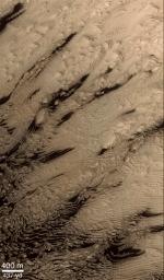
Hundreds of layers of similar thickness, texture, and pattern have been exposed by erosion in a 64 kilometer-wide (40 mile-wide) impact crater in western Arabia Terra at 8°N, 7°W. In other words, these layers provide a record of repeated, episodic changes that took place at some time far in the martian past, when this particular impact crater was the site of sediment deposition. Layers toward the center of the crater are nearly horizontal, but those closer to or draping over the crater walls are tilted (geologist use the term dipping) toward the basin center. These relationships suggest that the sediments that created these layers were deposited from above--perhaps by settling out of the martian atmosphere, or perhaps by settling out of water that might have occupied this crater as a lake.

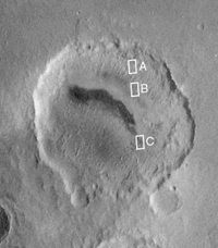
The context view (above) was taken by the Viking 1 orbiter in 1978; in it, north is up and sunlight illuminates the scene from the right. The three Mars Global Surveyor (MGS) Mars Orbiter Camera (MOC) narrow angle (high resolution) views (PIA02840, PIA02841 (this release), PIA02842) sample layer outcrops that were previously not known to exist in this crater. Each MOC image is illuminated from the left. Dark material in PIA02841 (this release) and PIA02840 is windblown sand; in PIA02840, this sand enhances the appearance of the layers.Note: In the context image above, the boxes marked A, B, and C refer to PIA02842, PIA02841 (this release), and PIA02840 respectively.

Image Credit:
NASA/JPL/MSSS

Image Addition Date:
2000-12-05