Images from Mariner 9 in 1972 revealed that some of the mesas and mounds found within the chasms of the martian "Grand Canyon"--the Valles Marineris--have layers in them. Speculations as to the origin of these interior layered materials ranged from volcanic ash deposits to sediments laid down in lakes that could have partially filled the Vallis Marineris troughs, much as lakes now occupy portions of the rift valleys of eastern Africa. The proposal that the Valles Marineris once hosted deep martian lakes led to additional speculation as to the prospects for finding fossil evidence of martian life.
Mars Global Surveyor (MGS) Mars Orbiter Camera (MOC) images have ten or more times better resolution than the Mariner 9 and Viking orbiter images taken in the 1970s. MOC images have indeed confirmed the presence of layered outcrops within the Valles Marineris. They have also shown places previously not suspected to have layered rock, and they have shown that these materials might not have formed in the Valles Marineris, but were instead deposited in craters that were subsequently buried long before the chasms opened up (see discussion below). The layered rock is now visible because of faulting and erosion.
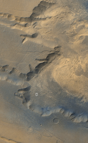
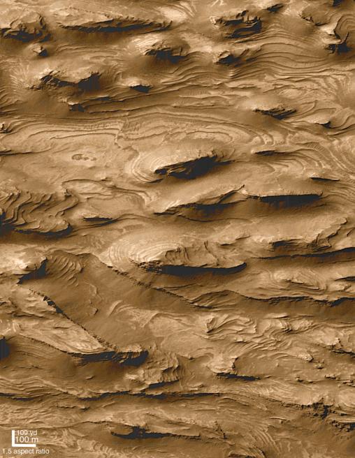
The high resolution picture shown here (B, above right) was the first image received by MOC scientists that began to hint at a larger story of layered sedimentary rock on Mars. The picture shows a 1.5 km by 2.9 km (0.9 mi by 1.8 mi) area in far southwestern Candor Chasma (A, above left) that was--based on Mariner 9 and Viking orbiter images--not previously expected to exhibit layers. The MOC image reveals that the floor of western Candor Chasma at this location is indeed layered. What is most striking about the picture is the large number and uniformity of the layers, or beds. There are over 100 beds in this area, and each has about the same thickness (estimated to be about 10 meters (11 yards) thick). Each layer has a relatively smooth upper surface, and each is hard enough to form steep cliffs at its margins.
Layers indicate change. The uniform pattern seen here--beds of similar properties and thickness repeated over a hundred times--suggest that the deposition of materials that made the layers was interrupted at regular or episodic intervals. Patterns like this, when found on Earth, usually indicate the presence of sediment deposited in dynamic, energetic, underwater environments. On Mars, these same patterns could very well indicate that the materials were deposited in a lake or shallow sea. Other MOC images suggest that these layers would not have formed in a lake in Candor Chasma, but instead were deposited in a crater or other basin that existed before Candor Chasma was cut (by faulting and erosion) into the surrounding terrain. However, it is not known for certain that these materials actually formed underwater, for it is possible that there were uniquely Martian processes occurring in the distant past that would mimic the pattern of sedimentation in water. For example, if the early Martian atmosphere was denser than it is today, and if the planet's atmospheric pressure changed on a cyclic basis (as it does today), then perhaps these materials are simply deposits of airborne dust that were later buried and cemented to create cliff-forming rock.
Sunlight illuminates both the wide angle context view and the narrow angle high resolution image from the left/upper left. In both, north is toward the top and east to the right.
 Planetary Data System


