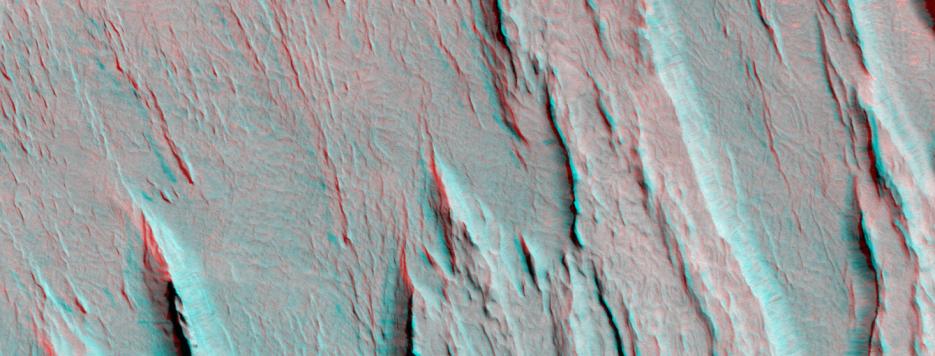
Layers of bedrock etched by wind to form sharp, elongated ridges known to geomorphologists as yardangs are commonplace in the southern Elysium Planitia/southern Amazonis region of Mars. The ridges shown in this 3-D composite of two overlapping Mars Global Surveyor (MGS) Mars Orbiter Camera (MOC) images occur in the eastern Aeolis region of southern Elysium Planitia near 2.3°S, 206.8°W. To view the picture in stereo, you need red-blue 3-D glasses (red filter over the left eye, blue over the right). For wind to erode bedrock into the patterns seen here, the rock usually must consist of something that is fine-grained and of nearly uniform grain size, such as sand. It must also be relatively easy to erode. For decades, most Mars researchers have interpreted these materials to be eroded deposits of volcanic ash. Nothing in the new picture shown here can support nor refute this earlier speculation. The entire area is mantled by light-toned dust. Small landslides within this thin dust layer form dark streaks on some of the steeper slopes in this picture (for more examples and explanations for these streaks, see previous web pages listed below).
The stereo (3-D) picture was compiled using an off-nadir view taken by the MOC during the Aerobrake-1 subphase of the mission in January 1998 with a nadir (straight-down-looking) view acquired in October 2000. The total area shown is about 6.7 kilometers (4.2 miles) wide by 2.5 kilometers (1.5 miles) high and is illuminated by sunlight from the upper right. The relief in the stereo image is quite exaggerated: the ridges are between about 50 and 100 meters (about 165-330 feet) high. North is toward the lower right.