- Original Caption Released with Image:
-
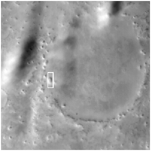
 The Mars Global Surveyor Mars Orbiter Camera narrow angle image (top) shows what, at first glance, might look like a "hot crossed bun" on the martian northern plains. The context for this landform is shown in the picture on the right. Unlike the southern highlands of Mars, the northern plains are lower and have far fewer impact craters on them. The relatively few craters that are present in the north have been severely eroded and/or buried. The context image shows a circle of mounds on the northern plains near the Phlegra Montes. These mounds were once the rim of a crater formed by impact of a meteorite. The mound in the high-resolution view (top) has been cracked and was at one time mostly covered by a thin veneer of light-toned material that is now seen only partly covering it. These two pictures were taken simultaneously on August 16, 1999, and occur near 45.9°N, 191.1°W. Both images are illuminated by sunlight from the lower right, the high resolution picture covers an area 3 km (1.9 mi) wide by 10.8 km (6.7 mi) long; the context image is about 115 km (71 miles) on a side. The bright, wispy features in the context image are clouds, their dark shadows can be seen cast upon the surface to the right of each cloud feature.
- Image Credit:
-
NASA/JPL/MSSS
Image Addition Date: -
2000-05-22
|

