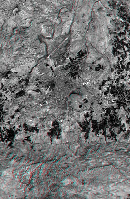
On January 26, 2001, the city of Bhuj suffered the most deadly earthquake in India's history. About 20,000 were killed and more than one million homes were damaged or destroyed. Shortly after the quake, geologists conducted field investigations to inventory and analyze the natural effects of the event. Stereoscopic views, similar to this anaglyph, aided the geologists in locating landforms indicative of long-term (and possibly ongoing) deformation. Soon, elevation data from the Shuttle Radar Topography Mission (SRTM) will be used in the study of a wide variety of natural hazards worldwide.
In this image, the city of Bhuj appears as a medium gray area at the scene center, and the city airport is toward the north (top). Vegetation appears very dark. Rugged but low relief hills of previously folded and faulted bedrock appear south (bottom) and northwest (upper-left) of the city.
The stereoscopic effect of this anaglyph was created by first draping a Landsat satellite image (taken just two weeks after the earthquake) over preliminary digital elevation data from the SRTM and then generating two differing perspectives, one for each eye. When viewed through special glasses, the result is a vertically exaggerated view of the Earth's surface in its full three dimensions. Anaglyph glasses cover the left eye with a red filter and cover the right eye with a blue filter.
Landsat has been providing visible and infrared views of the Earth since 1972. SRTM elevation data matches the 30-meter resolution of most Landsat images and will substantially help in analyses of the large and growing Landsat image archive. The Landsat7 Thematic Mapper image used here was provided to the SRTM project by the United States Geological Survey, Earth Resources Observation Systems (EROS) Data Center,Sioux Falls, South Dakota.
Elevation data used in this image was acquired by the Shuttle Radar Topography Mission (SRTM) aboard the Space Shuttle Endeavour, launched on February 11, 2000. SRTM used the same radar instrument that comprised the Spaceborne Imaging Radar-C/X-Band Synthetic Aperture Radar (SIR-C/X-SAR) that flew twice on the Space Shuttle Endeavour in 1994. SRTM was designed to collect three-dimensional measurements of the Earth's surface. To collect the 3-D data, engineers added a 60-meter-long (200-foot) mast, installed additional C-band and X-band antennas, and improved tracking and navigation devices. The mission is a cooperative project between the National Aeronautics and Space Administration (NASA), the National Imagery and Mapping Agency (NIMA) of the U.S. Department of Defense (DoD), and the German and Italian space agencies. It is managed by NASA's Jet Propulsion Laboratory, Pasadena, CA, for NASA's Earth Science Enterprise, Washington, DC.
Size: 13.5 x 20.6 kilometers ( 8.4 x 12.8 miles)
Location: 23.3 deg. North lat., 69.7 deg. East lon.
Orientation: North toward the top
Image Data: Landsat Band 3
Date Acquired: February 2000 (SRTM), February 9, 2001 (Landsat)
