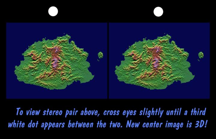
The Sovereign Democratic Republic of the Fiji Islands, commonly known as Fiji, is an independent nation consisting of some 332 islands surrounding the Koro Sea in the South Pacific Ocean. This topographic image shows Viti Levu, the largest island in the group. With an area of 10,429 square kilometers (about 4000 square miles), it comprises more than half the area of the Fiji Islands. Suva, the capital city, lies on the southeast shore. The Nakauvadra, the rugged mountain range running from north to south, has several peaks rising above 900 meters (about 3000 feet). Mount Tomanivi, in the upper center, is the highest peak at 1324 meters (4341 feet). The distinct circular feature on the north shore is the Tavua Caldera, the remnant of a large shield volcano that was active about 4 million years ago. Gold has been mined on the margin of the caldera since the 1930s. The Nadrau plateau is the low relief highland in the center of the mountain range. The coastal plains in the west, northwest and southeast account for only 15 percent of Viti Levu's area but are the main centers of agriculture and settlement.
This stereoscopic view was generated using preliminary topographic data from the Shuttle Radar Topography Mission. A computer-generated artificial light source illuminates the elevation data from the top (north) to produce a pattern of light and shadows. Slopes facing the light appear bright, while those facing away are shaded. Also, colors show the elevation as measured by SRTM. Colors range from green at the lowest elevations to pink at the highest elevations. This image contains about 1300 meters (4300 feet) of total relief. The stereoscopic effect was created by first draping the shading and colors back over the topographic data and then generating two differing perspectives, one for each eye. The 3-D perception is achieved by viewing the left image with the right eye and the right image with the left eye (cross-eyed viewing), or by downloading and printing the image pair and viewing them with a stereoscope. When stereoscopically merged, the result is a vertically exaggerated view of the Earth's surface in its full three dimensions.
This image was acquired by SRTM aboard the Space Shuttle Endeavour, launched on February 11, 2000. SRTM used the same radar instrument that comprised the Spaceborne Imaging Radar-C/X-Band Synthetic Aperture Radar (SIR-C/X-SAR) that flew twice on the Space Shuttle Endeavour in 1994. SRTM was designed to collect three-dimensional measurements of the Earth's surface. To collect the 3-D data, engineers added a 60-meter-long (about 200 feet) mast, installed additional C-band and X-band antennas, and improved tracking and navigation devices. The mission is a cooperative project between the National Aeronautics and Space Administration (NASA), the National Imagery and Mapping Agency (NIMA) of the U.S. Department of Defense (DoD), and the German and Italian space agencies. It is managed by NASA's Jet Propulsion Laboratory, Pasadena, CA, for NASA's Earth Science Enterprise, Washington, DC.
Size: 192 km (119 miles) x 142 km (88 miles)
Location: 17.8 deg. South lat., 178.0 deg. East lon.
Orientation: North at top
Date Acquired: February 19, 2000
Image: NASA/JPL/NIMA
 Planetary Data System


