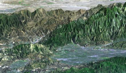
The San Fernando Valley (lower right of center) is part of Los Angeles and includes well over one million people. Two major disasters have occurred here in the last few decades: the 1971 Sylmar earthquake and the 1994 Northridge earthquake. Both quakes caused major damage to homes, freeways, and other structures and included major injuries and fatalities. The Northridge earthquake was the one of the costliest natural disasters in United States history. Understanding earthquake risks requires understanding a location's geophysical setting, and topographic data are of substantial benefit in that regard. Landforms are often characteristic of specific tectonic processes, such as ground movement along faults. Elevation models, such as those produced by the Shuttle Radar Topography Mission (SRTM), are particularly useful in visualizing regional scale landforms that are too large to be seen directly on-site. They can also be used to model the propagation of damaging seismic waves, which helps in urban planning. In recent years, elevation models have also been a critical input to radar interferometric studies, which reveal detailed patterns of ground deformation from earthquakes that had never before been seen.
This perspective view was generated by draping a Landsat satellite image over a preliminary topographic map from SRTM. Landsat has been providing visible and infrared views of the Earth since 1972. SRTM elevation data matches the 30-meter resolution of most Landsat images and will substantially help in analyses of the large and growing Landsat image archive.
The elevation data used in this image was acquired by SRTM aboard the Space Shuttle Endeavour, launched on February 11, 2000. SRTM used the same radar instrument that comprised the Spaceborne Imaging Radar-C/X-Band Synthetic Aperture Radar (SIR-C/X-SAR) that flew twice on the Space Shuttle Endeavour in 1994. SRTM was designed to collect three-dimensional measurements of the Earth's surface. To collect the 3-D data, engineers added a 60-meter-long (200-foot) mast, installed additional C-band and X-band antennas, and improved tracking and navigation devices. The mission is a cooperative project between the National Aeronautics and Space Administration (NASA), the National Imagery and Mapping Agency (NIMA) of the U.S. Department of Defense (DoD), and the German and Italian space agencies. It is managed by NASA's Jet Propulsion Laboratory, Pasadena, CA, for NASA's Earth Science Enterprise, Washington, DC.
Size: 33 kilometers (20 miles) view width, 88 kilometers (55 miles) view distance
Location: 34.2 deg. North lat., 118.5 deg. West lon.
Orientation: View toward the northeast, 3X vertical exaggeration
Image: Landsat bands 1, 2&4, 3 as blue, green, and red, respectively
Date Acquired: February 16, 2000 (SRTM), November 11, 1986 (Landsat)

 Planetary Data System


