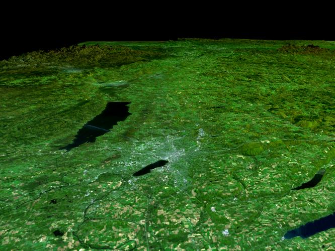
In the lower center of this perspective view of upstate New York, the city of Syracuse hugs the southeastern banks (top right side) of Lake Onondaga, the smaller of the two dark features that dominate the scene. The view is toward the east. The urban area appears bright in stark contrast to the dark waterways and the greens, browns and yellows of the vegetated areas. Both of the two black features are lakes. Oneida Lake, the larger of the two is to the left of the scene center. About 1/3 of the way between Lakes Onondaga and Oneida are the triangular shaped runways of the Syracuse Hancock International Airport. The Adirondack Mountains are to the upper left while the less rugged Catskills can be seen in the upper right. A faint outline of the Mohawk River can be seen as threads its way down from the Adirondacks toward the city of Rome, the bright area in the valley between the lake and the Adirondacks. The Erie Canal and the Oswego River are part of the network of waterways seen in the left image foreground.
Fall foliage in a variety of colors can be seen in the Landsat data used here. Redder vegetation generally occurs at higher elevations and toward the north (left), especially in the Adirondack Mountains. The back edge of the data set forms a false skyline. The image was generated using topographic data from SRTM and enhanced true-color Landsat 5 satellite images. Topographic shading in the image was enhanced with false shading derived from the elevation model. Topographic expression is exaggerated 6X. Syracuse lies at the geographic center of the state of New York and has been the site of its state fair for most of that event's 154 years. It is located in an agricultural and resort area. The yellowish rectangular features in the foreground of the image are farmlands. Parts of Skaneateles and Otisco Lakes, some of central New York's Finger Lakes, can be seen in the bottom right corner of the image.
Elevation data used in this image was acquired by the Shuttle Radar Topography Mission (SRTM) aboard the Space Shuttle Endeavour, launched on February 11, 2000. SRTM used the same radar instrument that comprised the Spaceborne Imaging Radar-C/X-Band Synthetic Aperture Radar (SIR-C/X-SAR) that flew twice on the Space Shuttle Endeavour in 1994. SRTM was designed to collect three-dimensional measurements of the Earth's surface. To collect the 3-D data, engineers added a 60-meter-long (200-foot) mast, installed additional C-band and X-band antennas, and improved tracking and navigation devices. The mission is a cooperative project between the National Aeronautics and Space Administration (NASA), the National Imagery and Mapping Agency (NIMA) of the U.S. Department of Defense (DoD), and the German and Italian Space agencies. It is managed by NASA's Jet Propulsion Laboratory, Pasadena, CA, for NASA's Earth Science Enterprise, Washington, DC.
Size: 200 kilometers View Distance x 280 kilometers View Width (Background) (125 by 175 miles)
Location: 43.1 deg. North Lat, 76.1.deg. West Lon. (Syracuse)
Orientation: View is toward the east
Date Acquired: SRTM, February 13, 2000; Landsat, various
 Planetary Data System


