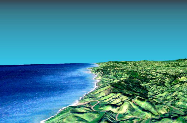
This 3-D perspective view looks south along the southeast coast of the North Island of New Zealand. The capital city of Wellington is off the right side of the image. The river in the foreground reaches the coast at the town of Owahanga. The point protruding east (left) in the middle of the image is Castlepoint. The dark green areas are thick pine forests. The Wairarapa valley is in the far distance at the righthand side.
This image shows how elevation data collected by the Shuttle Radar Topography Mission (SRTM) can be used to enhance other satellite images. In this case color and natural shading were provided by images collected by the Landsat 4Thematic Mapper in 1989. The terrain perspective was derived from SRTM elevation data acquired in February. Topography is not vertically exaggerated.
Elevation data used in this image was acquired by the Shuttle Radar Topography Mission (SRTM) aboard the Space Shuttle Endeavour, launched on February 11, 2000. SRTM used the same radar instrument that comprised the Spaceborne Imaging Radar-C/X-Band Synthetic Aperture Radar (SIR-C/X-SAR) that flew twice on the Space Shuttle Endeavour in 1994. SRTM was designed to collect three-dimensional measurements of the Earth's surface. To collect the 3-D data, engineers added a 60-meter-long (200-foot) mast, installed additional C-band and X-band antennas, and improved tracking and navigation devices. The mission is a cooperative project between the National Aeronautics and Space Administration (NASA), the National Imagery and Mapping Agency (NIMA) of the U.S. Department of Defense (DoD), and the German and Italian space agencies. It is managed by NASA's Jet Propulsion Laboratory, Pasadena, CA, for NASA's Earth Science Enterprise,Washington, DC.
The University of Oxford Department of Earth Sciences provided the Landsat data.
Size: scale varies in this perspective
Center location: 40.9 deg. south lat., 170.3 deg. east lon.
Orientation: view looking south
Original data resolution: 30 meters (99 feet)
Date acquired: SRTM: February 20, 2000; Landsat: June 13, 1989