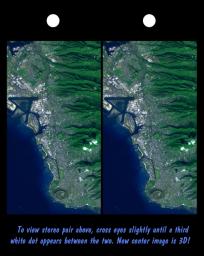
Honolulu, on the island of Oahu, is a large and growing urban area. This stereoscopic image pair, combining a Landsat image with topography measured by the Shuttle Radar Topography Mission (SRTM), shows how topography controls the urban pattern. This color image can be viewed in 3-D by viewing the left image with the right eye and the right image with the left eye (cross-eyed viewing), or by downloading and printing the image pair, and viewing them with a stereoscope.
Features of interest in this scene include Diamond Head (an extinct volcano near the bottom of the image), Waikiki Beach (just above Diamond Head), the Punchbowl National Cemetary (another extinct volcano, near the image center), downtown Honolulu and Honolulu harbor (image left-center), and offshore reef patterns. The slopes of the Koolau mountain range are seen in the right half of the image. Clouds commonly hang above ridges and peaks of the Hawaiian Islands, but in this synthesized stereo rendition appear draped directly on the mountains. The clouds are actually about 1000 meters (3300 feet) above sea level.
This stereoscopic image pair was generated using topographic data from the Shuttle Radar Topography Mission, combined with a Landsat 7 Thematic Mapper image collected at the same time as the SRTM flight. The topography data were used to create two differing perspectives, one for each eye. When stereoscopically merged, the result is a vertically exaggerated view of the Earth's surface in its full three dimensions. The United States Geological Survey's Earth Resources Observations Systems (EROS) Data Center, Sioux Falls, South Dakota, provided the Landsat data.
The Shuttle Radar Topography Mission (SRTM), launched on February 11, 2000, used the same radar instrument that comprised the Spaceborne Imaging Radar-C/X-Band Synthetic Aperture Radar (SIR-C/X-SAR) that flew twice on the Space Shuttle Endeavour in 1994. The mission was designed to collect three-dimensional measurements of the Earth's surface. To collect the 3-D data, engineers added a 60-meter-long (200-foot) mast, an additional C-band imaging antenna and improved tracking and navigation devices. The mission is a cooperative project between the National Aeronautics and Space Administration (NASA), the National Imagery and Mapping Agency (NIMA) and the German (DLR) and Italian (ASI) space agencies. It is managed by NASA's Jet Propulsion Laboratory, Pasadena, CA, for NASA's Earth Science Enterprise, Washington, DC.
Size: 11 by 20 kilometers (7 by 13 miles)
Location: 21.3 deg. North lat., 157.9 deg. West lon.
Orientation: North toward upper right
Original Data Resolution: SRTM, 30 meters (99 feet); Landsat, 15 meters (50 feet)
Date Acquired: SRTM, February 18, 2000; Landsat February 12, 2000
Image: NASA/JPL/NIMA

 Planetary Data System


