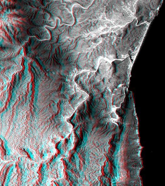
This 3-D view of a coastal area in southernmost Oman shows how topographic information can be used to enhance satellite images, deriving a better understanding of the processes that sculpt the landscape. The coastline in the upper half of the image appears to follow the same trend as a canyon in the lower half of the image. Both features are probably coincident with a single fault that cuts the limestone bedrock. Note how in this climate limestone erodes sharply along the stream courses resulting in deep and narrow canyons. Generally the landscape is barren, but the darker areas have sparse vegetation that is supported by summer monsoon moisture. The Arabian Sea is on the right.
This anaglyph was generated by first draping a Landsat Thematic Mapper image over a topographic map from the Shuttle Radar Topography Mission, then using the topographic data to create two differing perspectives, one for each eye. When viewed through special glasses, the result is a vertically exaggerated view of the Earth's surface in its full three dimensions. Anaglyph glasses cover the left eye with a red filter and cover the right eye with a blue filter.
Landsat satellites have provided visible light and infrared images of the Earth continuously since 1972. SRTM topographic data match the 30 meter (100 foot) spatial resolution of most Landsat images and will provide a valuable complement for studying the historic and growing Landsat data archive. The Landsat 7 Thematic Mapper image used here was provided to the SRTM project by the United States Geological Survey, Earth Resources Observation Systems (EROS) Data Center, Sioux Falls, South Dakota.
The Shuttle Radar Topography Mission (SRTM), launched on February 11, 2000, used the same radar instrument that comprised the Spaceborne Imaging Radar-C/X-Band Synthetic Aperture Radar (SIR-C/X-SAR) that flew twice on the Space Shuttle Endeavour in 1994. The mission was designed to collect three-dimensional measurements of the Earth's surface. To collect the 3-D data, engineers added a 60-meter-long (200-foot) mast, an additional C-band imaging antenna and improved tracking and navigation devices. The mission is a cooperative project between the National Aeronautics and Space Administration (NASA), the National Imagery and Mapping Agency (NIMA) and the German (DLR) and Italian (ASI) space agencies. It is managed by NASA's Jet Propulsion Laboratory, Pasadena, CA, for NASA's Earth Science Enterprise, Washington, DC.
Size: 20.5 by 18.3 kilometers (12.7 by 11.3 miles)
Location: 16.9 deg. North lat., 53.7 deg. East lon.
Orientation: North at top-left
Date Acquired: February 15, 2000
Image: NASA/JPL/NIMA
 Planetary Data System


