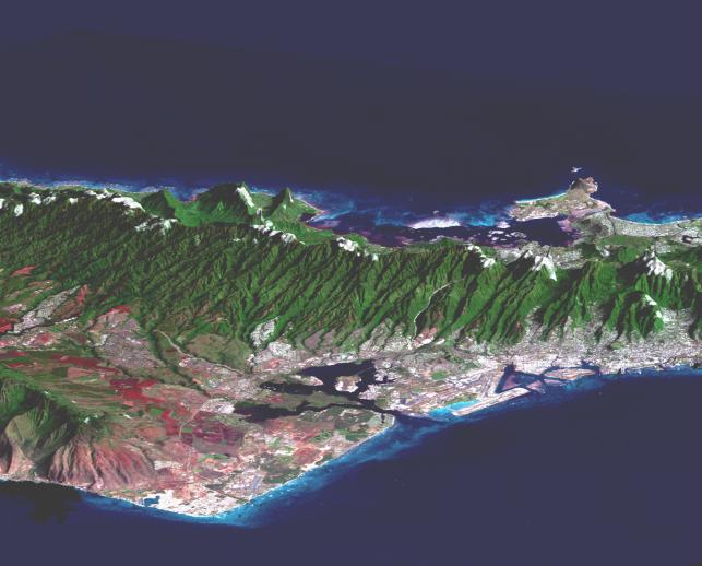
Honolulu, on the island of Oahu, is a large and growing urban area with limited space and water resources. This perspective view, combining a Landsat image with SRTM topography, shows how the topography controls the urban growth pattern, causes cloud formation, and directs the rainfall runoff pattern. Features of interest in this scene include downtown Honolulu (right), Honolulu Harbor (right), Pearl Harbor (center), and offshore reef patterns (foreground). The Koolau mountain range runs through the center of the image. On the north shore of the island are the Mokapu Peninsula and Kaneohe Bay (upper right). Clouds commonly hang above ridges and peaks of the Hawaiian Islands, and in this rendition appear draped directly on the mountains. The clouds are actually about 1000 meters (3300 feet) above sea level. High resolution topographic and image data allow ecologists and planners to assess the effects of urban development on the sensitive ecosystems in tropical regions.
This type of display adds the important dimension of elevation to the study of land use and environmental processes as observed in satellite images. The perspective view was created by draping a Landsat 7 satellite image over an SRTM elevation model. Topography is exaggerated about six times vertically. The Landsat 7 image was acquired on February 12, 2000, and was provided by the United States Geological Survey's Earth Resources Observations Systems (EROS) data Center, Sioux Falls, South Dakota.
The Shuttle Radar Topography Mission (SRTM), launched on February 11, 2000, uses the same radar instrument that comprised the Spaceborne Imaging Radar-C/X-Band Synthetic Aperture Radar (SIR-C/X-SAR) that flew twice on the Space Shuttle Endeavour in 1994. The mission is designed to collect three-dimensional measurements of the Earth's surface. To collect the 3-D data, engineers added a 60-meter-long (200-foot) mast, an additional C-band imaging antenna and improved tracking and navigation devices. The mission is a cooperative project between the National Aeronautics and Space Administration (NASA), the National Imagery and Mapping Agency (NIMA) and the German (DLR) and Italian (ASI) space agencies. It is managed by NASA's Jet Propulsion Laboratory, Pasadena, CA, for NASA's Earth Science Enterprise, Washington, DC.
Size: 28 by 56 kilometers (17 by 35 miles)
Location: 21.4 deg. North lat., 157.8 deg. West lon.
Orientation: Looking North
Original Data Resolution: SRTM, 30 meters (99 feet); Landsat, 15 meters (50 feet)
Date Acquired: SRTM, February 18, 2000; Landsat February 12, 2000
 Planetary Data System


