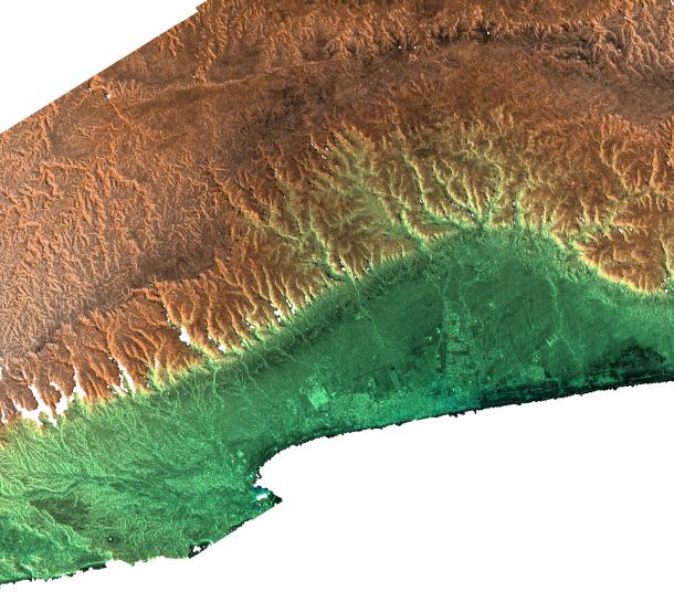
This radar image includes the city of Salalah, the second largest city in Oman. It illustrates how topography determines local climate and, in turn, where people live. This area on the southern coast of the Arabian Peninsula is characterized by a narrow coastal plain (bottom) facing southward into the Arabian Sea, backed by the steep escarpment of the Qara Mountains. The backslope of the Qara Mountains slopes gently into the vast desert of the Empty Quarter (at top). This area is subject to strong monsoonal storms from the Arabian Sea during the summer, when the mountains are enveloped in a sort of perpetual fog. The moisture from the monsoon enables agriculture on the Salalah plain, and also provides moisture for Frankincense trees growing on the desert (north) side of the mountains. In ancient times, incense derived from the sap of the Frankincense tree was the basis for an extremely lucrative trade. Radar and topographic data are used by historians and archaeologists to discover ancient trade routes and other significant ruins.
This image combines two types of data from the Shuttle Radar Topography Mission. The image brightness corresponds to the strength of the radar signal reflected from the ground, while colors show the elevation as measured by SRTM. Colors range from green at the lowest elevations to brown at the highest elevations. This image contains about 1070 meters (3500 feet) of total relief. White speckles on the face of some of the mountains are holes in the data caused by steep terrain. These will be filled using coverage from an intersecting pass.
The Shuttle Radar Topography Mission (SRTM), launched on February 11, 2000, uses the same radar instrument that comprised the Spaceborne Imaging Radar-C/X-Band Synthetic Aperture Radar (SIR-C/X-SAR) that flew twice on the Space Shuttle Endeavour in 1994. The mission is designed to collect three-dimensional measurements of the Earth's surface. To collect the 3-D data, engineers added a 60-meter-long (200-foot) mast, an additional C-band imaging antenna and improved tracking and navigation devices. The mission is a cooperative project between the National Aeronautics and Space Administration (NASA), the National Imagery and Mapping Agency (NIMA) and the German (DLR) and Italian (ASI) space agencies. It is managed by NASA's Jet Propulsion Laboratory, Pasadena, CA, for NASA's Earth Science Enterprise,Washington, DC.
Size: 56 by 50 kilometers (35 by 32 miles)
Location: 17 deg. North lat., 54 deg. East lon.
Orientation: North at top
Date Acquired: February 15, 2000
 Planetary Data System


