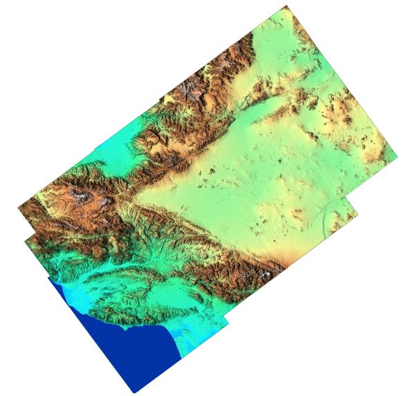
"From the desert to the mountains to the sea," this image shows in striking detail the varied topography of Southern California. The data, which cover an area one and a half times the size of New Jersey, were acquired in 15 seconds by the Shuttle Radar Topography Mission (SRTM). The large V-shape across the center of the image is the intersection of the mountains uplifted along two major faults. The San Andreas Fault is the lower part of the "V" and the Garlock Fault is the upper part. Between the faults is the western Mojave Desert, including the alternate landing site for the Shuttle at Edwards Air Force Base, near the center of the image. The Pacific Coast appears in the lower left of the image, from Oxnard at the left center edge, curving southeast to Los Angeles. The flat blue area along the top is the southern end of California's Central Valley. Along the right edge of the image is NASA's Goldstone Deep Space Tracking Station. Scientists will use data like these to study a broad range of topics, including ecology, the environment, geology, as well as to make assessments of seismic, flood, and wildfire hazards.
This shaded relief image was generated using topographic data from the Shuttle Radar Topography Mission. A computer-generated artificial light source illuminates the elevation data to produce a pattern of light and shadows. Slopes facing the light appear bright, while those facing away are shaded. On flatter surfaces, the pattern of light and shadows can reveal subtle features in the terrain. Colors show the elevation as measured by SRTM. Colors range from blue at the lowest elevations to white at the highest elevations. This image contains about 3000 meters (10,000 feet) of total relief. White speckles on the face of some of the mountains are holes in the data caused by steep terrain. These will be filled using coverage from an intersecting pass.
The Shuttle Radar Topography Mission (SRTM), launched on February 11, 2000, uses the same radar instrument that comprised the Spaceborne Imaging Radar-C/X-Band Synthetic Aperture Radar (SIR-C/X-SAR) that flew twice on the Space Shuttle Endeavour in 1994. The mission is designed to collect three-dimensional measurements of the Earth's surface. To collect the 3-D data, engineers added a 60-meter-long (200-foot) mast, an additional C-band imaging antenna and improved tracking and navigation devices. The mission is a cooperative project between the National Aeronautics and Space Administration (NASA), the National Imagery and Mapping Agency (NIMA) and the German (DLR) and Italian (ASI) space agencies. It is managed by NASA's Jet Propulsion Laboratory, Pasadena, CA, for NASA's Earth Science Enterprise, Washington, DC.
Size: 250 km (155 miles) x 150 km (93 miles)
Location: 34.8 deg. North lat., 118.0 deg. West lon.
Orientation: North at top
Original Data Resolution: 30 meters (99 feet)
Date Acquired: February 16, 2000
 Planetary Data System


