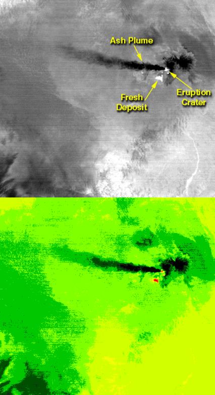
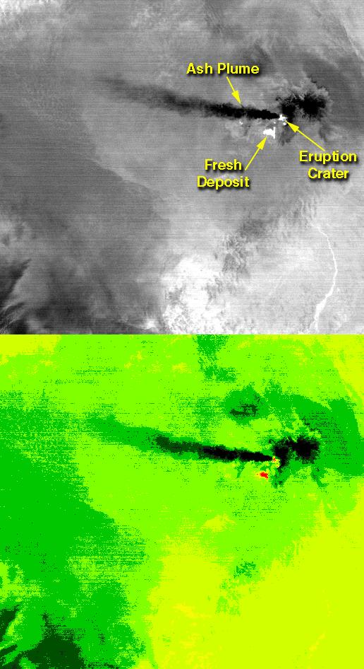
On the night of June 4, 2001 ASTER captured this thermal image of the erupting Shiveluch volcano. Located on Russia's Kamchatka Peninsula, Shiveluch rises to an altitude of 8028'. The active lava dome complex is seen as a bright (hot) area on the summit of the volcano. To the southwest, a second hot area is either a debris avalanche or hot ash deposit. Trailing to the west is a 25 km ash plume, seen as a cold "cloud" streaming from the summit. At least 60 large eruptions have occurred during the last 10,000 years; the largest historical eruptions were in 1854 and 1964. Because Kamchatka is located along the major aircraft routes between North America/Europe and the Far East, this area is constantly monitored for potential ash hazards to aircraft. The lower image is the same as the upper, except it has been color coded: red is hot, light greens to dark green are progressively colder, and gray/black are the coldest areas.
The image is located at 56.7 degrees north latitude, 161.3 degrees east longitude.
Advanced Spaceborne Thermal Emission and Reflection Radiometer (ASTER) is one of five Earth-observing instruments launched December 18, 1999, on NASA's Terra satellite. The instrument was built by Japan's Ministry of International Trade and Industry. A joint U.S./Japan science team is responsible for validation and calibration of the instrument and the data products. Dr. Anne Kahle at NASA's Jet Propulsion Laboratory, Pasadena, Calif., is the U.S. Science team leader; Moshe Pniel of JPL is the project manager. ASTER is the only high resolution imaging sensor on Terra. The primary goal of the ASTER mission is to obtain high-resolution image data in 14 channels over the entire land surface, as well as black and white stereo images. With revisit time of between 4 and 16 days, ASTER will provide the capability for repeat coverage of changing areas on Earth's surface.
The broad spectral coverage and high spectral resolution of ASTER will provide scientists in numerous disciplines with critical information for surface mapping, and monitoring dynamic conditions and temporal change. Example applications are: monitoring glacial advances and retreats, monitoring potentially active volcanoes, identifying crop stress, determining cloud morphology and physical properties, wetlands Evaluation, thermal pollution monitoring, coral reef degradation, surface temperature mapping of soils and geology, and measuring surface heat balance.