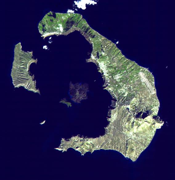
This ASTER image of Santorini was acquired on November 21, 2000 and covers an area of 18 by 18 km. The eruption of Santorini in 1650 B.C. was one of the largest in the last 10,000 years. About 30 cubic kilometers of magma was erupted, forming a plinian column 36 km high. The removal of such a large volume of magma caused the volcano to collapse, producing a caldera. Ash fell over a large area of the eastern Mediterranean. The eruption probably caused the end of the Minoan civilization on the island of Crete. The largest island is Thera, and the smaller is Therasia. The Kameni Islands (dark in the image center) formed after the caldera., with the most recent eruptions occurring in 1950.
The image is centered at 36.4 degrees north latitude, 25.4 degrees east longitude.
Advanced Spaceborne Thermal Emission and Reflection Radiometer (ASTER) is one of five Earth-observing instruments launched December 18, 1999, on NASA's Terra satellite. The instrument was built by Japan's Ministry of International Trade and Industry. A joint U.S./Japan science team is responsible for validation and calibration of the instrument and the data products. Dr. Anne Kahle at NASA's Jet Propulsion Laboratory, Pasadena, Calif., is the U.S. Science team leader; Moshe Pniel of JPL is the project manager. ASTER is the only high resolution imaging sensor on Terra. The primary goal of the ASTER mission is to obtain high-resolution image data in 14 channels over the entire land surface, as well as black and white stereo images. With revisit time of between 4 and 16 days, ASTER will provide the capability for repeat coverage of changing areas on Earth's surface.
The broad spectral coverage and high spectral resolution of ASTER will provide scientists in numerous disciplines with critical information for surface mapping, and monitoring dynamic conditions and temporal change. Example applications are: monitoring glacial advances and retreats, monitoring potentially active volcanoes, identifying crop stress, determining cloud morphology and physical properties, wetlands Evaluation, thermal pollution monitoring, coral reef degradation, surface temperature mapping of soils and geology, and measuring surface heat balance.
 Planetary Data System


