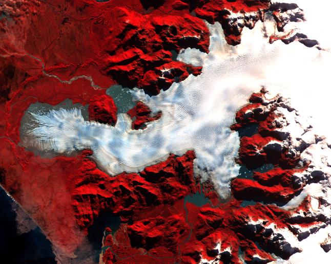
This ASTER image was acquired on May 2, 2000 over the North Patagonia Ice Sheet, Chile near latitude 47 degrees south, longitude 73 degrees west. The image covers 36 x 30 km. The false color composite displays vegetation in red. The image dramatically shows a single large glacier, covered with crevasses. A semi-circular terminal moraine indicates that the glacier was once more extensive than at present. ASTER data are being acquired over hundreds of glaciers worldwide to measure their changes over time. Since glaciers are sensitive indicators of warming or cooling, this program can provide global data set critical to understand climate change.
This image is located at 46.5 degrees south latitude and 73.9 degrees west longitude.
Advanced Spaceborne Thermal Emission and Reflection Radiometer (ASTER) is one of five Earth-observing instruments launched December 18, 1999, on NASA's Terra satellite. The instrument was built by Japan's Ministry of International Trade and Industry. A joint U.S./Japan science team is responsible for validation and calibration of the instrument and the data products. Dr. Anne Kahle at NASA's Jet Propulsion Laboratory, Pasadena, Calif., is the U.S. Science team leader; Moshe Pniel of JPL is the project manager. ASTER is the only high resolution imaging sensor on Terra. The primary goal of the ASTER mission is to obtain high-resolution image data in 14 channels over the entire land surface, as well as black and white stereo images. With revisit time of between 4 and 16 days, ASTER will provide the capability for repeat coverage of changing areas on Earth's surface.
The broad spectral coverage and high spectral resolution of ASTER will provide scientists in numerous disciplines with critical information for surface mapping, and monitoring dynamic conditions and temporal change. Example applications are: monitoring glacial advances and retreats, monitoring potentially active volcanoes, identifying crop stress, determining cloud morphology and physical properties, wetlands Evaluation, thermal pollution monitoring, coral reef degradation, surface temperature mapping of soils and geology, and measuring surface heat balance.
 Planetary Data System


