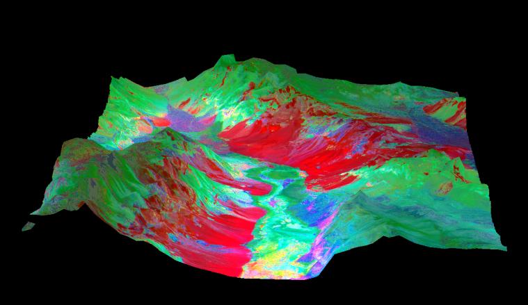
This 3-D perspective view looking north over Death Valley, California, was produced by draping ASTER nighttime thermal infrared data over topographic data from the US Geological Survey. The ASTER data were acquired April 7, 2000 with the multi-spectral thermal infrared channels, and cover an area of 60 by 80 km (37 by 50 miles). Bands 13, 12, and 10 are displayed in red, green and blue respectively. The data have been computer enhanced to exaggerate the color variations that highlight differences in types of surface materials. Salt deposits on the floor of Death Valley appear in shades of yellow, green, purple, and pink, indicating presence of carbonate, sulfate, and chloride minerals. The Panamint Mtns. to the west, and the Black Mtns. to the east, are made up of sedimentary limestones, sandstones, shales, and metamorphic rocks. The bright red areas are dominated by the mineral quartz, such as is found in sandstones; green areas are limestones. In the lower center part of the image is Badwater, the lowest point in North America.
Advanced Spaceborne Thermal Emission and Reflection Radiometer (ASTER) is one of five Earth-observing instruments launched December 18, 1999, on NASA's Terra satellite. The instrument was built by Japan's Ministry of International Trade and Industry. A joint U.S./Japan science team is responsible for validation and calibration of the instrument and the data products. Dr. Anne Kahle at NASA's Jet Propulsion Laboratory, Pasadena, Calif., is the U.S. Science team leader; Moshe Pniel of JPL is the project manager. ASTER is the only high resolution imaging sensor on Terra. The primary goal of the ASTER mission is to obtain high-resolution image data in 14 channels over the entire land surface, as well as black and white stereo images. With revisit time of between 4 and 16 days, ASTER will provide the capability for repeat coverage of changing areas on Earth's surface.
The broad spectral coverage and high spectral resolution of ASTER will provide scientists in numerous disciplines with critical information for surface mapping, and monitoring dynamic conditions and temporal change. Example applications are: monitoring glacial advances and retreats, monitoring potentially active volcanoes, identifying crop stress, determining cloud morphology and physical properties, wetlands Evaluation, thermal pollution monitoring, coral reef degradation, surface temperature mapping of soils and geology, and measuring surface heat balance.
 Planetary Data System


