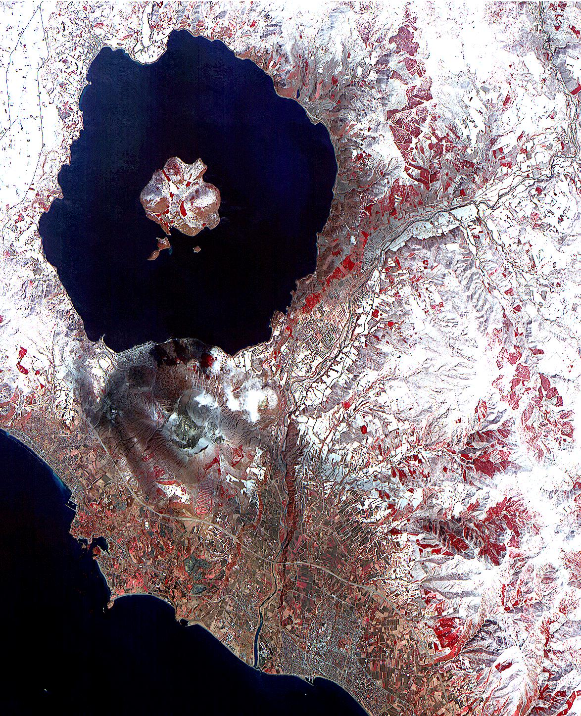
On April 3, the Advanced Spaceborne Thermal Emission and Reflection Radiometer (ASTER) on NASA's Terra Satellite captured this image of the erupting Mt. Usu volcano in Hokkaido, Japan. With its 14 spectral bands from the visible to the thermal infrared wavelength region, and its high spatial resolution of 15 to 90 meters (about 50 to 300 feet), ASTER will image the Earth for the next 6 years to map and monitor the changing surface of our planet.
This false color infrared image of Mt Usu volcano is dominated by Lake Toya, an ancient volcanic caldera. On the south shore is the active Usu volcano. On Friday, March 31, more than 11,000 people were evacuated by helicopter, truck and boat from the foot of Usu, that began erupting from the northwest flank, shooting debris and plumes of smoke streaked with blue lightning thousands of feet in the air. Although no lava gushed from the mountain, rocks and ash continued to fall after the eruption. The region was shaken by thousands of tremors before the eruption. People said they could taste grit from the ash that was spewed as high as 2,700 meters (8,850 ft) into the sky and fell to coat surrounding towns with ash. "Mount Usu has had seven significant eruptions that we know of, and at no time has it ended quickly with only a small scale eruption," said Yoshio Katsui, a professor at Hokkaido University. This was the seventh major eruption of Mount Usu in the past 300 years. Fifty people died when the volcano erupted in 1822, its worst known eruption.
In the image, most of the land is covered by snow. Vegetation, appearing red in the false color composite, can be seen in the agricultural fields, and forests in the mountains. Mt. Usu is crossed by three dark streaks. These are the paths of ash deposits that rained out from eruption plumes two days earlier. The prevailing wind was from the northwest, carrying the ash away from the main city of Date. Ash deposited can be traced on the image as far away as 10 kilometers (16 miles) from the volcano.
Advanced Spaceborne Thermal Emission and Reflection Radiometer (ASTER) is one of five Earth-observing instruments launched December 18, 1999, on NASA's Terra satellite. The instrument was built by Japan's Ministry of International Trade and Industry. A joint U.S./Japan science team is responsible for validation and calibration of the instrument and the data products. Dr. Anne Kahle at NASA's Jet Propulsion Laboratory, Pasadena, California, is the U.S. Science team leader; Moshe Pniel of JPL is the project manager. ASTER is the only high resolution imaging sensor on Terra. The primary goal of the ASTER mission is to obtain high-resolution image data in 14 channels over the entire land surface, as well as black and white stereo images. With revisit time of between 4 and 16 days, ASTER will provide the capability for repeat coverage of changing areas on Earth's surface.
The broad spectral coverage and high spectral resolution of ASTER will provide scientists in numerous disciplines with critical information for surface mapping, and monitoring dynamic conditions and temporal change. Example applications are: monitoring glacial advances and retreats; monitoring potentially active volcanoes; identifying crop stress; determining cloud morphology and physical properties; wetlands evaluation; thermal pollution monitoring; coral reef degradation; surface temperature mapping of soils and geology; and measuring surface heat balance.
 Planetary Data System


