These images of the Island of Hawaii were acquired on March 19, 2000 by the Advanced Spaceborne Thermal Emission and Reflection Radiometer (ASTER) on NASA's Terra satellite. With its 14 spectral bands from the visible to the thermal infrared wavelength region, and its high spatial resolution of 15 to 90 meters (about 50 to 300 feet), ASTER will image Earth for the next 6 years to map and monitor the changing surface of our planet. Data are shown from the short wavelength and thermal infrared spectral regions, illustrating how different and complementary information is contained in different parts of the spectrum.
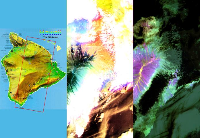
Left image: This false-color image covers an area 60 kilometers (37 miles) wide and 120 kilometers (75 miles) long in three bands of the short wavelength infrared region. While, much of the island was covered in clouds, the dominant central Mauna Loa volcano, rising to an altitude of 4115 meters (13,500 feet), is cloud-free. Lava flows can be seen radiating from the central crater in green and black tones. As they reach lower elevations, the flows become covered with vegetation, and their image color changes to yellow and orange. Mauna Kea volcano to the north of Mauna Loa has a thin cloud-cover, producing a bluish tone on the image. The ocean in the lower right appears brown due to the color processing.
Right image: This image is a false-color composite of three thermal infrared bands. The brightness of the colors is proportional to the temperature, and the hues display differences in rock composition. Clouds are black, because they are the coldest objects in the scene. The ocean and thick vegetation appear dark green because they are colder than bare rock surfaces, and have no thermal spectral features. Lava flows are shades of magenta, green, pink and yellow, reflecting chemical changes due to weathering and relative age differences.
Advanced Spaceborne Thermal Emission and Reflection Radiometer (ASTER) is one of five Earth-observing instruments launched December 18, 1999, on NASA's Terra satellite. The instrument was built by Japan's Ministry of International Trade and Industry. A joint U.S./Japan science team is responsible for validation and calibration of the instrument and the data products. Dr. Anne Kahle at NASA's Jet Propulsion Laboratory, Pasadena, California, is the U.S. Science team leader; Moshe Pniel of JPL is the project manager. ASTER is the only high resolution imaging sensor on Terra. The primary goal of the ASTER mission is to obtain high-resolution image data in 14 channels over the entire land surface, as well as black and white stereo images. With revisit time of between 4 and 16 days, ASTER will provide the capability for repeat coverage of changing areas on Earth's surface.
The broad spectral coverage and high spectral resolution of ASTER will provide scientists in numerous disciplines with critical information for surface mapping, and monitoring dynamic conditions and temporal change. Example applications are: monitoring glacial advances and retreats; monitoring potentially active volcanoes; identifying crop stress; determining cloud morphology and physical properties; wetlands evaluation; thermal pollution monitoring; coral reef degradation; surface temperature mapping of soils and geology; and measuring surface heat balance.