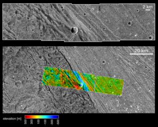
These images, taken by NASA's Galileo spacecraft on its May 20, 2000, flyby of Jupiter's moon Ganymede, illustrate the boundary and different elevations between the dark, ancient terrain of Nicholson Regio (left) and bright, younger terrain of Harpagia Sulcus (right.) The bottom image is a wide view of the boundary, and the top image is an enlargement of the colorized strip.
An important goal of Galileo's Ganymede encounter was to understand the nature of the boundary between ancient, dark terrain and younger, bright terrain. The camera was aimed at the boundary to obtain both very high-resolution images (top) and medium-resolution context images(bottom). Color-coded elevations are indicated relative to the average elevation of the sampled area, with high elevation marked in red, and low in blue. Combining the two image mosaics allows scientists to derive a detailed description of the region from the overlap. The data shows that there are approximately 200 meters (about 650 feet) of topographic relief within the bright terrain here, and a deep depression marks the boundary between bright and dark terrains.
North is to the top of the pictures. The Sun illuminates the surface from the left. The larger image, centered at ?14 degrees latitude and 319 degrees longitude, covers an area approximately 213 by 97 kilometers (132 by 60 miles.) The resolution of the high-resolution image is 20 meters (about 65 feet) per picture element, and the context image is at 121 meters (397 feet) per picture element. The higher resolution image was taken at a range of 2000 kilometers (over 1,200 miles).
The Jet Propulsion Laboratory, Pasadena, Calif., manages the Galileo mission for NASA's Office of Space Science, Washington, D.C. JPL is a division of the California Institute of Technology in Pasadena.
This image and other images and data received from Galileo are posted on the Galileo mission home page at http://www.jpl.nasa.gov/galileo . The images were produced by the German Aerospace Center (DLR)http://solarsystem.dlr.de/, and Brown University,http://www.planetary.brown.edu/. Background information and educational context for the images can be found at http://www.jpl.nasa.gov/galileo/sepo.

 Planetary Data System


