Click for full-resolution image | 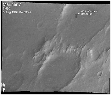
Click for full-resolution image |
Click for full-resolution image | 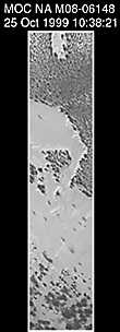
Click for full-resolution image |
As we head into the 21st Century, it seems hard to believe that human beings have been sending spacecraft toward Mars for more than 3 decades already. The first spacecraft to reach Mars was Mariner 4 in 1965. This success was followed by two spacecraft in 1969, Mariners 6 and 7. Now the wonders and alien beauty of Mars continue to unfold with each day that the Mars Global Surveyor -- which arrived in September 1997 -- continues to radio its data to Earth.
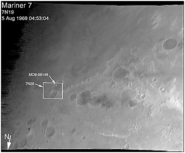
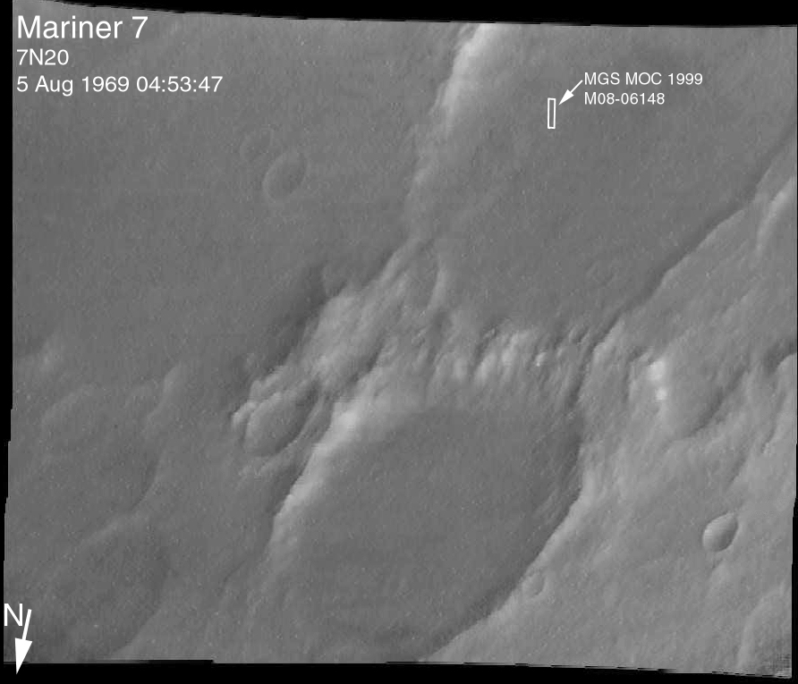
Mars exploration was always difficult and each bit of data returned from the planet is a marvel. On August 5, 1969, the Mariner 7 spacecraft flew past Mars at a minimum altitude of about 4200 km. It acquired 14 wide/narrow angle image pairs during the few minutes of the "near encounter" flyby. One of these image pairs, 7N19/7N20, shows the south polar region and contains a feature that at the time was nicknamed "the Giant's Footprint." Shown in the first two pictures, above, the feature consists of two adjoining craters, one about 80 km (50 mi) in diameter and the other about 50 km (31 mi) across near latitude 76°S, longitude 276°W. The oblique geometry of the Mariner 7 image enhances the impression of a footprint.
The "Giant's Footprint" was almost missed when Mariner 7 suffered a near-catastrophic battery failure just a few days before the encounter -- on July 30 -- that put the spacecraft sporadically out of contact with Earth for two days. Ground controllers at the Jet Propulsion Laboratory (JPL) recovered the spacecraft, re-planned its imaging sequence based on results from the Mariner 6 flyby on July 31, and salvaged all of the mission's science goals in under a week!
In the 1970's, the larger crater in "giant's footprint" was named "Vishniac" in honor of Wolf Vishniac, an American microbiologist of the University of Rochester who was instrumental in the development of methods to search for life on Mars. Vishniac was tragically killed in a fall in Antarctica in 1973 while retrieving a life detection experiment, and the crater was named in honor of this "giant" in the search for life on Mars.
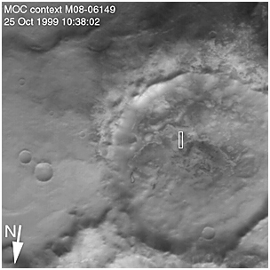
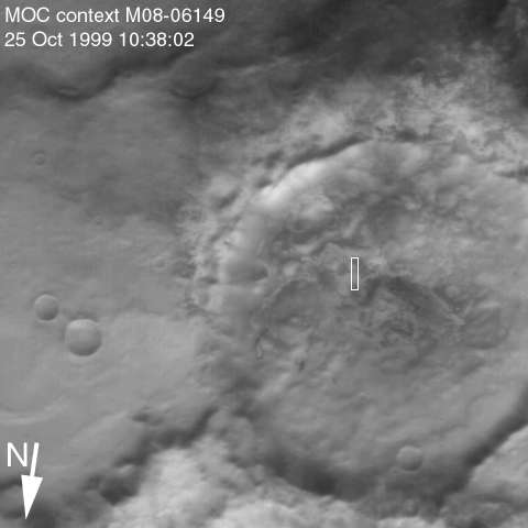
More than three decades after the Mariner 7 flyby, Mars Global Surveyor's Mars Orbiter Camera (MOC) acquired a commemorative view of the interior of Vishniac Crater on October 25, 1999. The context image and the 3-meters (9.8 feet)-per-pixel narrow angle view are shown above (in the lower image pair). Mariner 7's 7N20 has a nominal resolution of about 180 meters (591 feet) per pixel, while the MOC high resolution view is about 60 times higher (in actuality, the lower quality of the Mariner 7 images makes the resolution gain even more dramatic).
The MOC high resolution view (lower right, above) shows a 1.5 kilometer-(0.9 mile)-wide portion of the floor of Vishniac in the process of defrosting during southern spring. The bright areas are still frost-covered, while the darker areas are either defrosted or composed of darkened or "dirty" frost. The dark patches in the image seem to serve as sources for dark streaks of material that has either been blown across the landscape by wind, or has somehow caused the erosion of frost to create the streaks. Dark streaks follow the local topography, as might the wind that blew across this landscape. This pattern of spots and streaks was quite common on the defrosting south polar cap during the spring that lasted from early August 1999 to late December 1999.
All images shown here are illuminated by sunlight from the lower right. Image orientation with north toward the bottom was selected in order to show the "footprint" visible in Mariner 7 image 7N20. The Mariner 7 images were recovered at Malin Space Science Systems from the original 7-track magnetic tapes, archived on CD-ROM by the JPL Data Preservation activity.


