(A) Polar Lander landing site ellipses. | 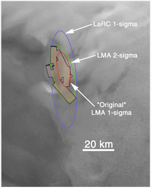
(B) MOC coverage (orange) to 17 Jan. 2000. |
(C) MOC image mosaic to 17 Jan. 2000. | 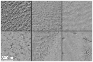
(D) Sample high resolution views from MOC mosaic. |
Since mid-December 1999, the Mars Orbiter Camera (MOC) onboard the Mars Global Surveyor (MGS) spacecraft has been taking pictures of Mars Polar Lander's landing zone near 76°S, 195°W, in hopes of finding some evidence as to the fate of the spacecraft that went missing during its December 3, 1999, landing attempt. To take these pictures, the MGS spacecraft is pointed a few degrees off its normal, nadir-looking (straight down) path. The first phase of imaging was completed December 24, 1999, but nothing was found. A second, expanded search was requested by the Mars Surveyor Operations Project and was begun in early January 2000.The MOC operations team at Malin Space Science Systems has been busy with the Mars Polar Lander search since December 3rd -- initial efforts focused on the use of MOC as a buffer or "storage space" for data relayed through the MGS Mars Relay (MR) system. It had been hoped that the Polar Lander would try to communicate to Earth using its UHF antenna to relay data through the MGS relay system. Data from the relay come through the MOC and are received at Malin Space Science Systems much in the same way that pictures from MOC are obtained. The relay effort was concluded on January 17, 2000, with no word from the Polar Lander. Meanwhile, the MOC operations team began to plan, command, retrieve, and analyze images designed to look for the Polar Lander. These pictures are taken at the highest spatial resolution possible for MOC, 1.5 meters (5 ft.) per pixel. At this resolution, the fuselage and wings of a jumbo jet can be distinguished, but a Polar Lander would only be a few pixels, at most, in size.
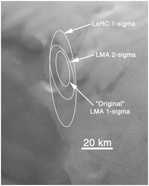
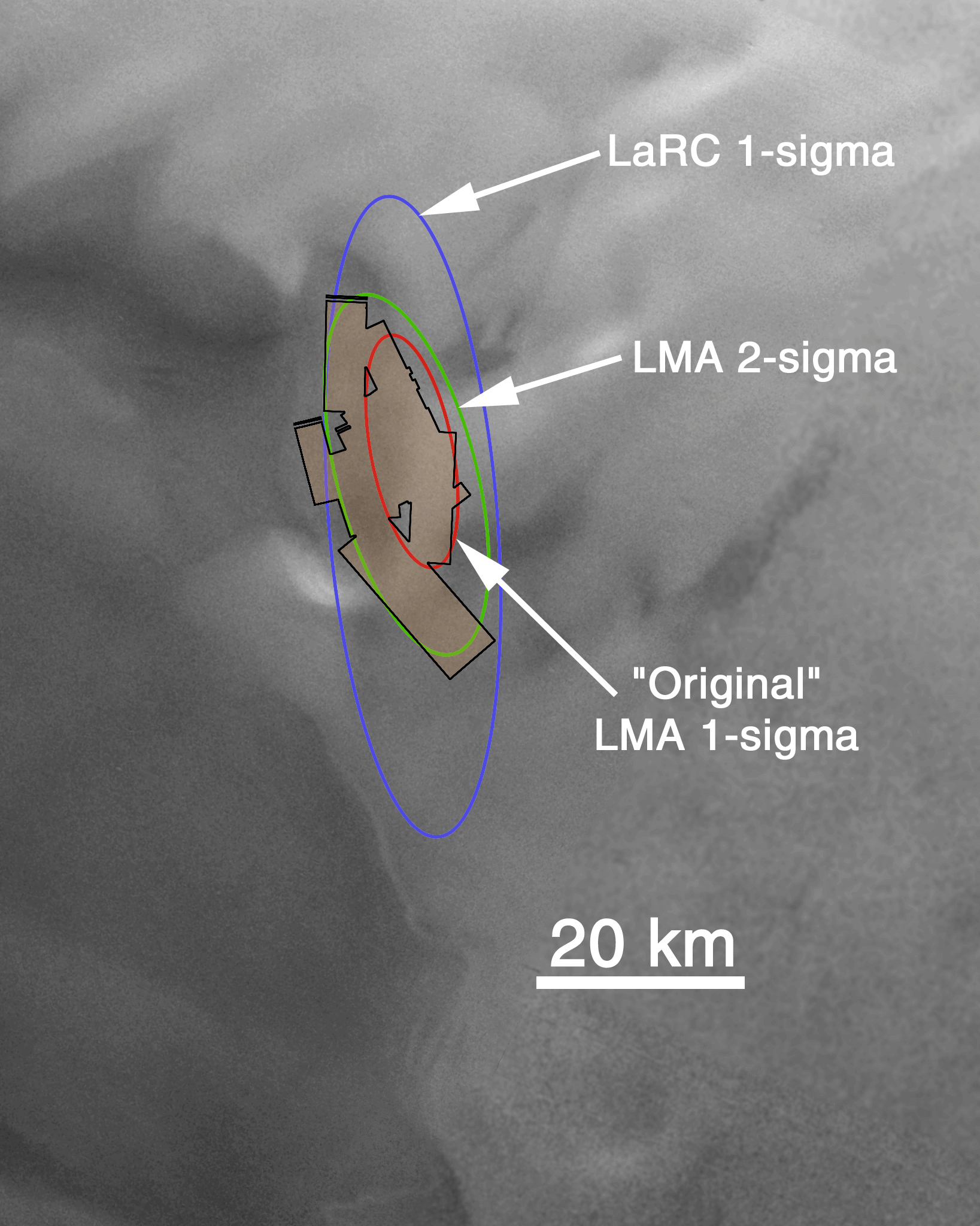
The first illustration (A, above) shows the area being searched by MOC. All images shown here are oriented such that north is up and west is to the left, and all are illuminated by sunlight from the upper left. The ellipses indicate the regions in which the Polar Lander may have touched down. The larger ellipse was derived by NASA's Langley Research Center (LaRC); the two smaller ellipses were calculated by the Mars Polar Lander contractor, Lockheed Martin Astronautics (LMA). The smallest ellipse is the target that was given to the MOC team shortly after Polar Lander recovery attempts began in mid-December 1999. All MOC images obtained through December 26, 1999, were targeted to this smaller ellipse -- images were taken both on the "2 a.m." and "2 p.m." sides of Mars, with better sunlight conditions, of course, being available on the 2 p.m. side. After the first of the year (2000), further refinement of the entry parameters and atmospheric conditions at the time of landing allowed additional, different trajectories to be examined. LMA's revised ellipses were offset from the original ellipse, and LaRC's were much larger. The two larger ellipses shown above were given to the MOC team for targeting on the 2 p.m. side of Mars starting during the second week of January 2000.
The second figure (B, above) shows (in orange) the area covered by MOC from mid-December through January 17, 2000. Gaps between and within individual images have been caused by loss of data during transmission to Earth, combined with occasional uncertainties in spacecraft predicted positions.
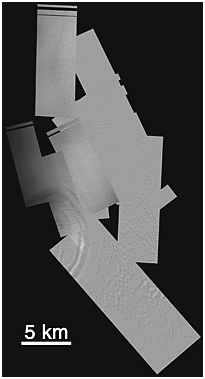
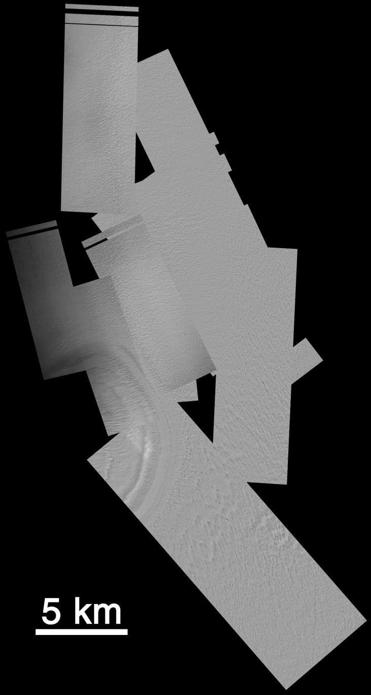
The third picture (C, above) is a mosaic of the MOC images obtained through January 17, 2000, that cover the Mars Polar Lander landing ellipses. Available here are two views designed to fit on a page in your web browser: one in which the 1.5 meter (5 ft) per pixel images have been shrunk to 15 meters (49 ft) per pixel, the other in which they have been shrunk to 30 meters (98 ft) per pixel. The most obvious feature in the mosaic is toward the lower left -- about one-half of a crater-like circular depression is seen. More than 330 square kilometers (127 sq. miles) of south polar terrain have been imaged at 1.5 meters per pixel for this effort.
The fourth picture (D, above) shows some samples of the variety of terrains and textures present within Mars Polar Lander's landing zone. Each of the six boxes shows an area of equal size. Knobs, pits, ridges, gullies, and smooth intervening surfaces are all seen.
The task of finding the lander in these images is daunting. As shown in our previous release, "Mars Polar Lander: The Search Begins," December 21, 1999, the lander is most likely to consist of only a few square pixels within one of these images. Thus, the MOC team is basically trying to distinguish one or two pixels from nearly 150 million. One team member has remarked that this is like "trying to find a specific needle in...a haystack-sized pile of needles."


